Page 1 of 1
Bonogin to Springbrook via rocky outcrop and creamtrack
Posted: Tue 30 Apr, 2013 8:18 am
by dtbaker
Hello everybody,
Back 10 or so years ago a guy named Dave Farrer(?)/Farrell(?)/Hawkeye(?) took a group of us scouts on a walk from his property in Bonogin up to Springbrook.
It was a full day walk. Rather difficult and involving quite a bit of machete use.
I am trying to find out if this is a "walk" or more of a private property thing, as I would love to do it again now that I'm older.
My memory of the event is rather sketchy, but here goes:
- we started near the end of bonogin road
- there were a couple of rocky peaks that we went around (he had an old notebook that told him which side of the peak was safe to go on)
- there was lots of wait a while and lantana
- we stopped on a large rocky outcrop, possibly on the top of one of these peaks.
- outcrop was large enough to hold about 15 of us, had some dangerous drop off, we were not allowed to go past a certain point.
- view from outcrop (to the left?) was a banana plantation, possibly some power lines and a little shed
- there was a bit of climbing involved in getting up to the rocky outcrop
- some point during the walk we reached the summit of another hill that had a small cleared area and a little post. apparently you could camp there as we were planning our next overnight adventure to stay there.
- near the beginning of the walk was a tree that bad a branch grown in a loop, apparently only the locals knew about this
Initially I thought this was the cougals, but I was pretty certain we started from his property in bonogin and tracking over to cougals before hitting the cream track from bonogin seems a bit too much
Does anybody know another rocky outcrop that might match this description? or is it the cougals?
Thanks!
Dave
Re: Bonogin to Springbrook via rocky outcrop and creamtrack
Posted: Wed 08 May, 2013 9:53 pm
by gentlemanbushwalker
Hey dtbaker, check out my post about Bally Mountain which is now state owned land at the end of Bonogin road
viewtopic.php?f=48&t=10973Is is possible that these are the outcrops you are referring to? Seems likely. Bally mtn has a little marker on top and the rocky outcrop you are taking about is on the east side.
Re: Bonogin to Springbrook via rocky outcrop and creamtrack
Posted: Sat 25 May, 2013 12:07 pm
by tas-man
dtbaker wrote:Hello everybody,
Back 10 or so years ago a guy named Dave Farrer(?)/Farrell(?)/Hawkeye(?) took a group of us scouts on a walk from his property in Bonogin up to Springbrook.
It was a full day walk. Rather difficult and involving quite a bit of machete use.
There is a lot of discussion in this thread
viewtopic.php?f=38&t=6689 that includes the Cougals, and access to Springbrook via the Cream Track. I took a group on a day walk from Tallebudgera Creek to the top of Springbrook along the Cream (or Jeep) Track in the 1970's and can recall the thick lantana and wait-a-while that took a lot of machette work on the way up, but do not recall going over any rocky outcrops on the way. I have marked up a Google Earth 3D image with the general location of the track (with photos in referenced thread) . I doubt very much you went over the Cougals as the mention of views to the left of banana plantations discount Mt Cougal as the spot you were on, and your starting point of Bonogin Road is on the opposite side of Talebudgera Valley. Looking at the terrain on Google Earth. you most likely followed a ridgeline to Springbrook after climbing up from Bonogin Road and went over some rocky outcrops on this ridge as you get onto Mt Gannon. You would have met up with the Cream track where it goes through a cutting in the ridge and then up to join the Springbrook road. I attempted part of this route with Harley Smith and a mate from BBW but starting from the Smith's farm in Tallebudgera Creek. We spent an exhausting day hacking our way through lantana and vine thickets, spent a night out on the ridge and as rain had started overnight, decided to retrace our steps and give it a miss! We were thankful for the rain though giving us more than enough to drink off the tent roof, having carried a limited suppy for the two day attempt on Springbrook along this route.
dtbaker wrote:I am trying to find out if this is a "walk" or more of a private property thing, as I would love to do it again now that I'm older.<snip>
Thanks!
Dave
Check out the Mt Cougal/Springbrook thread which confirms that the route of the Cream track is on a Crown Land Road Reserve in spite of the signs at the end of Tallebudgera Cree kRoad that warn of private property restrictions. I have posted a scan of an old Springbrook NP map that shows the road reserve location, but best to check current details before picking your route to avoid issues with local landholders.
Re: Bonogin to Springbrook via rocky outcrop and creamtrack
Posted: Sat 25 May, 2013 1:00 pm
by tas-man
As the old adage says "a picture is worth a thousand words" here's a sketch of approximiate routes to clarify my understanding of possible route taken by Dave related to other tracks and landmarks mentioned.
Re: Bonogin to Springbrook via rocky outcrop and creamtrack
Posted: Sat 25 May, 2013 1:14 pm
by tas-man
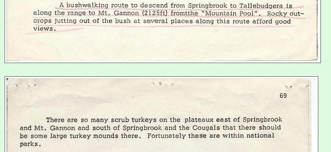
To clarify, the rocky outcrops marked in the photo above are on the end of Mt Gannon - more details in Harley Smith's UQBWC "Heybob" article on this page, especially the last paragraph underlined in red -
download/file.php?id=14670&mode=view
- Picture 4.png (245.47 KiB) Viewed 23726 times
Re: Bonogin to Springbrook via rocky outcrop and creamtrack
Posted: Thu 25 Jul, 2013 12:46 pm
by tas-man
tas-man wrote: <snip> I attempted part of this route with Harley Smith and a mate from BBW but starting from the Smith's farm in Tallebudgera Creek. We spent an exhausting day hacking our way through lantana and vine thickets, spent a night out on the ridge and as rain had started overnight, decided to retrace our steps and give it a miss! We were thankful for the rain though giving us more than enough to drink off the tent roof, having carried a limited suppy for the two day attempt on Springbrook along this route.
I found this one slide taken on the above trip taken while climbing the ridge behind the Smith's farm looking back to Boyd's Butte and Mt Cougal. Gives another perspective from the Tallebudgera Valley.
Re: Bonogin to Springbrook via rocky outcrop and creamtrack
Posted: Thu 25 Jul, 2013 1:20 pm
by tas-man
Looking at the location the above photo was taken from on Google Earth, my approximate track marked in an earlier post illustrating walking routes, was too far to the west - I would have been climbing the next ridge to the east of the purple track route. It is interesting to see the bush re-growth on the hillside in the middle distance that was then covered by a banana plantation.
Re: Bonogin to Springbrook via rocky outcrop and creamtrack
Posted: Fri 30 May, 2014 10:04 pm
by dtbaker
Sorry I missed all these replies! They must have gone to my spam inbox.
Well a week ago I managed to track down the guy who took us from bonogin to springbrook. He's done this track quite a few times since then.
I'm catching up with him to go over the details and trying to pencil in a date to do this again

Re: Bonogin to Springbrook via rocky outcrop and creamtrack
Posted: Sat 31 May, 2014 5:33 am
by KrazyKeith
I sure look forward to hearing about this - very keen to try it !
Re: Bonogin to Springbrook via rocky outcrop and creamtrack
Posted: Mon 02 Jun, 2014 8:45 pm
by tas-man
Looking forward to any up to date photos of this area that you can add to this thread.
Re: Bonogin to Springbrook via rocky outcrop and creamtrack
Posted: Thu 23 Oct, 2014 7:52 am
by Springbrook Girl
The owner of the property at the top of the Cream Track is about to fence what we all thought was road reserve and where the track was walkable.He has cleared with out a permit and will be putting up a very sturdy barb wire fence. It will make this track impassable as the forest on the actual road reserve is impenetrable.
Re: Bonogin to Springbrook via rocky outcrop and creamtrack
Posted: Thu 16 Jul, 2015 7:28 pm
by TheCreamTrack
The Cream Track is open... visit
http://www.TheCreamTrack.com.au for details.
It is true that a significant portion of the cream track at the Springbrook Mountain end is located on private property. I personally manage this private property, a working farm and Highland Cattle Stud and have done so for some years.
The Gold Coast Bushwalkers Club regularly walk The Cream Track and are a great resource if you wish to walk this track with experienced folks or obtain further information.
email:
[email protected]phone: 0490 488 064
post: PO Box 59, Miami, QLD, 4220
In order to allow walkers to legally traverse the private property sections of the track at the Springbrook end, simply visit the website
http://www.TheCreamTrack.com.au and fill out online application form for your free permit which will be issued to you automatically.
Download the KML property boundary file from the website to your GPS to ensure you remain on the road reserve for the Tallebudgera sector.
With best wishes to all
Greg Kernaghan
Property Manager
SERENITY
2940 - 3000 Springbrook Road
SPRINGBROOK QLD 4213
P.S. If any one would like to submit photos or stories for the web site
http://www.thecreamtrack.com.au to help tell the story and history - it would be much appreciated -these can be uploaded at www,thecreamtrack.com.au - thanks
Re: Bonogin to Springbrook via rocky outcrop and creamtrack
Posted: Sun 10 Jan, 2016 5:18 pm
by karma
My husband and I walked this yesterday, from the Tallebudgera end, and a lot of the land on this side is privately owned too. We talked to the owners of the private property on this side and it is not necessary to enter their land as there is now fluoro pink surveyor's tape that marks the original Cream Track, which walkers must follow or you will end up on their private property. Anyone who knows about the Cream track wants to follow the original anyway, so there is no need to trespass. Be fair to these people and follow the correct trail.