Curious NNW
I had a good look at the sign posted exclusion zone maps and I was definitely outside of those mapped areas.
I particularly noticed that the top pyramid area of Townsend was in the exclusion zone, but I was out on the ridge towards Alice Rawson.
On another thread someone mentioned the watershed rule and suggested that the limit was where a stone would roll the other way.
The Townsend map was clearly showing an area larger than that.
I might have been closer to it on Little Twynam - but I was not amongst the summit boulders but further down the eastern side with a steady drop down towards the valley to Guthega.
Edit - found it now - it might be on a thread, but this was in the Nat Parks official 2011 brochure on KNP - page 4!!.
Quotes:
"Camping is not permitted at any time within the catchments of all glacial lakes on the Main Range."
"The catchment comprises all the areas surrounding the lakes where rainfall could drain into the lakes via streams or as runoff.
Imagine dropping a ball from where you intend to camp. If the ball would roll into a lake (disregarding obstacles) you are in its
catchment"
It's curious that their maps posted on the track show the exclusion area a bit chunkier than this written rule implies - but I cannot find them on the web??
PPS - found the reference discussion here http://bushwalk.com/forum/viewtopic.php?f=36&t=5706
It shows an extract from Chapman that seems to put a campsite right next to Townsend & a photo of one of the posted maps along the track showing the greater extents - probably contradicting Chapman's advice. I was not inside any of these exclusion zones as pictured, but I was close to them.
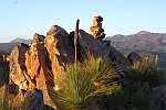
PPPS - I have edited the captions on my pictures to give more detail as to exactly where they were. The one with Townsend in could be misleading - there is quite a large saddle in between the rocks and the peak behind.
Tarptent the Moment
Forum rules
TIP: The online Bushwalk Inventory System can help bushwalkers with a variety of bushwalk planning tasks, including: Manage which items they take bushwalking so that they do not forget anything they might need, plan meals for their walks, and automatically compile food/fuel shopping lists (lists of consumables) required to make and cook the meals for each walk. It is particularly useful for planning for groups who share food or other items, but is also useful for individual walkers.
TIP: The online Bushwalk Inventory System can help bushwalkers with a variety of bushwalk planning tasks, including: Manage which items they take bushwalking so that they do not forget anything they might need, plan meals for their walks, and automatically compile food/fuel shopping lists (lists of consumables) required to make and cook the meals for each walk. It is particularly useful for planning for groups who share food or other items, but is also useful for individual walkers.
122 posts
• Page 5 of 5 • 1, 2, 3, 4, 5
Re: Tarptent the Moment
![]() by eggs » Fri 20 Jan, 2012 9:32 pm
by eggs » Fri 20 Jan, 2012 9:32 pm
-
eggs - Lagarostrobos franklinii

- Posts: 10860
- Joined: Fri 23 May, 2008 2:58 pm
- Location: Para Vista, South Australia
- Region: South Australia
Re: Tarptent the Moment
![]() by north-north-west » Fri 10 Feb, 2012 8:23 pm
by north-north-west » Fri 10 Feb, 2012 8:23 pm
Yeah, you're lower on both camps than I originally thought, although I was under the impression that much of the Alice Rawson area was also included.
Personally, I don't really see a problem with where people put their tents as long as their toilet and washing areas are outside the exclusion zones - unlike one chap I saw up on Townsend who was camped legally but went over to the Albina side of the ridge when he needed a dunny break . . .
Personally, I don't really see a problem with where people put their tents as long as their toilet and washing areas are outside the exclusion zones - unlike one chap I saw up on Townsend who was camped legally but went over to the Albina side of the ridge when he needed a dunny break . . .
"Mit der Dummheit kämpfen Götter selbst vergebens."
-

north-north-west - Lagarostrobos franklinii
- Posts: 15493
- Joined: Thu 14 May, 2009 7:36 pm
- Location: The Asylum
- ASSOCIATED ORGANISATIONS: Social Misfits Anonymous
- Region: Tasmania
122 posts
• Page 5 of 5 • 1, 2, 3, 4, 5
Who is online
Users browsing this forum: No registered users and 64 guests