Indeed Eggs and impressive! Looks like you are going to dominate this thread also.
This is the Simatai section of the Great Wall, the famed 'Sky Bridge'/'Heavenly Ladder', all a part of UNESCOs World Cultural Heritage sites. This section is part of what's known as the "wild" sections of the Great Wall where there's little or no maintenance in modern days, unlike Badaling which is both fully renovated and extremely heavy on tourism. These wild sections are typically far more spectacular and have a real back-to-history feel. Whilst there are warning and off-limit signs, one can walk/climb/scramble along them for miles and miles. CM, the track is the Wall itself where once soldiers marched for hundreds of miles. Yes, I was standing on the wall when these photos were taken. The best part is, Simatai section is just to the north-east of Beijing and easily accessible (N40.620224, E117.424144).
Over to you Eggs.
Game: Where-is-it? (international)
Forum rules
Only administrators may post new topics to this forum. Registered users can post replies.
Only administrators may post new topics to this forum. Registered users can post replies.
-

GPSGuided - Lagarostrobos franklinii

- Posts: 6968
- Joined: Mon 13 May, 2013 2:37 pm
- Location: Sydney
- Region: New South Wales
Re: Game: Where-is-it? (international)
![]() by eggs » Sun 04 Jan, 2015 7:42 am
by eggs » Sun 04 Jan, 2015 7:42 am
Looked good from the research.
Back to NZ for this one
Back to NZ for this one
- Lion Rock on the black sand beach at Piha
Last edited by eggs on Sun 04 Jan, 2015 7:53 am, edited 1 time in total.
-
eggs - Lagarostrobos franklinii
- Posts: 10466
- Joined: Fri 23 May, 2008 2:58 pm
- Location: Para Vista, South Australia
- Region: South Australia
Re: Game: Where-is-it? (international)
![]() by wayno » Sun 04 Jan, 2015 7:48 am
by wayno » Sun 04 Jan, 2015 7:48 am
south piha beach, lion rock
from the land of the long white clouds...
-

wayno - Lagarostrobos franklinii
- Posts: 8784
- Joined: Sun 19 Jun, 2011 7:26 am
- Location: NZ
- Region: New Zealand
- Gender: Male
Re: Game: Where-is-it? (international)
![]() by eggs » Sun 04 Jan, 2015 7:49 am
by eggs » Sun 04 Jan, 2015 7:49 am
Yes. A lovely black sand beach
-
eggs - Lagarostrobos franklinii
- Posts: 10466
- Joined: Fri 23 May, 2008 2:58 pm
- Location: Para Vista, South Australia
- Region: South Australia
Re: Game: Where-is-it? (international)
![]() by wayno » Sun 04 Jan, 2015 7:59 am
by wayno » Sun 04 Jan, 2015 7:59 am
see if you can work this one out... covers a well known track in NZ
- Attachments
-
from the land of the long white clouds...
-
wayno - Lagarostrobos franklinii
- Posts: 8784
- Joined: Sun 19 Jun, 2011 7:26 am
- Location: NZ
- Region: New Zealand
- Gender: Male
Re: Game: Where-is-it? (international)
![]() by GPSGuided » Sun 04 Jan, 2015 8:33 am
by GPSGuided » Sun 04 Jan, 2015 8:33 am
Can see a valley at the bottom right but hard to identify any named features. Going by regular airline routes, it has to be somewhere north of ZQN. Routeburn track?
Just move it!
-
GPSGuided - Lagarostrobos franklinii
- Posts: 6968
- Joined: Mon 13 May, 2013 2:37 pm
- Location: Sydney
- Region: New South Wales
Re: Game: Where-is-it? (international)
![]() by wayno » Sun 04 Jan, 2015 9:26 am
by wayno » Sun 04 Jan, 2015 9:26 am
no but you're in the right area, on the right hand side theres a couple of geological features that identify this track...
from the land of the long white clouds...
-
wayno - Lagarostrobos franklinii
- Posts: 8784
- Joined: Sun 19 Jun, 2011 7:26 am
- Location: NZ
- Region: New Zealand
- Gender: Male
Re: Game: Where-is-it? (international)
![]() by GPSGuided » Sun 04 Jan, 2015 11:19 am
by GPSGuided » Sun 04 Jan, 2015 11:19 am
Given the terrain and suggestion, Mt Cook/Mt Tasman must be somewhere in there... I need to be better educated on the various great walks there.
Just move it!
-
GPSGuided - Lagarostrobos franklinii
- Posts: 6968
- Joined: Mon 13 May, 2013 2:37 pm
- Location: Sydney
- Region: New South Wales
Re: Game: Where-is-it? (international)
![]() by wayno » Sun 04 Jan, 2015 11:23 am
by wayno » Sun 04 Jan, 2015 11:23 am
its close to the routeburn, not cook
from the land of the long white clouds...
-
wayno - Lagarostrobos franklinii
- Posts: 8784
- Joined: Sun 19 Jun, 2011 7:26 am
- Location: NZ
- Region: New Zealand
- Gender: Male
Re: Game: Where-is-it? (international)
![]() by eggs » Sun 04 Jan, 2015 2:17 pm
by eggs » Sun 04 Jan, 2015 2:17 pm
I can see Cascade Saddle and the Dart Glacier
-
eggs - Lagarostrobos franklinii
- Posts: 10466
- Joined: Fri 23 May, 2008 2:58 pm
- Location: Para Vista, South Australia
- Region: South Australia
Re: Game: Where-is-it? (international)
![]() by wayno » Mon 05 Jan, 2015 3:50 am
by wayno » Mon 05 Jan, 2015 3:50 am
eggs wrote:I can see Cascade Saddle and the Dart Glacier
correct
from the land of the long white clouds...
-
wayno - Lagarostrobos franklinii
- Posts: 8784
- Joined: Sun 19 Jun, 2011 7:26 am
- Location: NZ
- Region: New Zealand
- Gender: Male
Re: Game: Where-is-it? (international)
![]() by GPSGuided » Mon 05 Jan, 2015 3:53 am
by GPSGuided » Mon 05 Jan, 2015 3:53 am
Eggs, go for the kill!
Just move it!
-
GPSGuided - Lagarostrobos franklinii
- Posts: 6968
- Joined: Mon 13 May, 2013 2:37 pm
- Location: Sydney
- Region: New South Wales
Re: Game: Where-is-it? (international)
![]() by eggs » Mon 05 Jan, 2015 9:01 am
by eggs » Mon 05 Jan, 2015 9:01 am
Not sure what you mean?
I suspect the track wayno was after was the Cascade Saddle track.
The Rees/Dart track is out of view on the left of the picture, although the Rees Saddle is in view far left.
The valley in the bottom RHS is the West Branch of the Matukituki River - with a track leading to Cascade Hut [technically in view], Aspiring Hut and the Matukituki Saddle
Its a fantastically clear aerial shot.
Lets try a typical normal airliner grotty window view - what am I looking at in Africa?
- Morning light on Mt Kilamanjaro [5895m - Tanzania]
Last edited by eggs on Mon 05 Jan, 2015 10:53 am, edited 1 time in total.
-
eggs - Lagarostrobos franklinii
- Posts: 10466
- Joined: Fri 23 May, 2008 2:58 pm
- Location: Para Vista, South Australia
- Region: South Australia
Re: Game: Where-is-it? (international)
![]() by wayno » Mon 05 Jan, 2015 9:37 am
by wayno » Mon 05 Jan, 2015 9:37 am
kilimanjaro
from the land of the long white clouds...
-
wayno - Lagarostrobos franklinii
- Posts: 8784
- Joined: Sun 19 Jun, 2011 7:26 am
- Location: NZ
- Region: New Zealand
- Gender: Male
-
eggs - Lagarostrobos franklinii
- Posts: 10466
- Joined: Fri 23 May, 2008 2:58 pm
- Location: Para Vista, South Australia
- Region: South Australia
Re: Game: Where-is-it? (international)
![]() by wayno » Mon 05 Jan, 2015 12:38 pm
by wayno » Mon 05 Jan, 2015 12:38 pm
new Zealand, a couple of iconic peaks here to name...
- Attachments
-
from the land of the long white clouds...
-
wayno - Lagarostrobos franklinii
- Posts: 8784
- Joined: Sun 19 Jun, 2011 7:26 am
- Location: NZ
- Region: New Zealand
- Gender: Male
Game: Where-is-it? (international)
![]() by GPSGuided » Mon 05 Jan, 2015 4:43 pm
by GPSGuided » Mon 05 Jan, 2015 4:43 pm
Mt Cook on the left. The slope to the right. Was the photo taken from the same flight as the one earlier?
Just move it!
-
GPSGuided - Lagarostrobos franklinii
- Posts: 6968
- Joined: Mon 13 May, 2013 2:37 pm
- Location: Sydney
- Region: New South Wales
Re: Game: Where-is-it? (international)
![]() by wayno » Mon 05 Jan, 2015 5:02 pm
by wayno » Mon 05 Jan, 2015 5:02 pm
GPSGuided wrote:Mt Cook on the left. The slope to the right. Was the photo taken from the same flight as the one earlier?
correct, Mt Tasman to the right.. dont think it was the same flight, the flight paths have reversed
from the land of the long white clouds...
-
wayno - Lagarostrobos franklinii
- Posts: 8784
- Joined: Sun 19 Jun, 2011 7:26 am
- Location: NZ
- Region: New Zealand
- Gender: Male
Re: Game: Where-is-it? (international)
![]() by GPSGuided » Mon 05 Jan, 2015 5:38 pm
by GPSGuided » Mon 05 Jan, 2015 5:38 pm
Moving across the Pacific to North America and a 'where am I'. The bit of structures shown to the extreme left of the first photo and the city skyline with close-up should identify the locality and location, particularly noticeable if one sits on the starboard side of the plane on approach into this associated city. If you know the topology of the city well, you''ll also be able to identify the prominence in the centre distant of the first photo. At this location, there's a fair bit of significant scientific research going on along with lots of hiking trails.
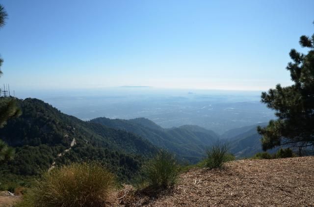
From Mt Wilson, part of the San Gabriel mountains range. Peaks at 1740m and overlooks the metropolis of Los Angeles. It has a network of pleasant wooded mountain trails surrounding it.
From Mt Wilson, part of the San Gabriel mountains range. Peaks at 1740m and overlooks the metropolis of Los Angeles. It has a network of pleasant wooded mountain trails surrounding it.
Last edited by GPSGuided on Tue 06 Jan, 2015 2:15 pm, edited 2 times in total.
Just move it!
-
GPSGuided - Lagarostrobos franklinii
- Posts: 6968
- Joined: Mon 13 May, 2013 2:37 pm
- Location: Sydney
- Region: New South Wales
Re: Game: Where-is-it? (international)
![]() by wayno » Mon 05 Jan, 2015 5:43 pm
by wayno » Mon 05 Jan, 2015 5:43 pm
vancouver
from the land of the long white clouds...
-
wayno - Lagarostrobos franklinii
- Posts: 8784
- Joined: Sun 19 Jun, 2011 7:26 am
- Location: NZ
- Region: New Zealand
- Gender: Male
Re: Game: Where-is-it? (international)
![]() by GPSGuided » Mon 05 Jan, 2015 5:50 pm
by GPSGuided » Mon 05 Jan, 2015 5:50 pm
Wrong country but correct coastline.
Just move it!
-
GPSGuided - Lagarostrobos franklinii
- Posts: 6968
- Joined: Mon 13 May, 2013 2:37 pm
- Location: Sydney
- Region: New South Wales
Re: Game: Where-is-it? (international)
![]() by wayno » Mon 05 Jan, 2015 6:00 pm
by wayno » Mon 05 Jan, 2015 6:00 pm
san fran cisco
from the land of the long white clouds...
-
wayno - Lagarostrobos franklinii
- Posts: 8784
- Joined: Sun 19 Jun, 2011 7:26 am
- Location: NZ
- Region: New Zealand
- Gender: Male
Re: Game: Where-is-it? (international)
![]() by GPSGuided » Mon 05 Jan, 2015 6:08 pm
by GPSGuided » Mon 05 Jan, 2015 6:08 pm
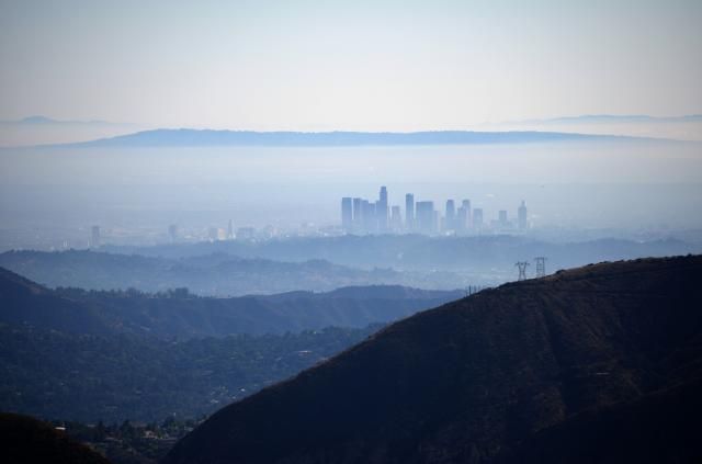
This city does not have a beautiful bay of water, see the first and second photo.
Just move it!
-
GPSGuided - Lagarostrobos franklinii
- Posts: 6968
- Joined: Mon 13 May, 2013 2:37 pm
- Location: Sydney
- Region: New South Wales
Re: Game: Where-is-it? (international)
![]() by wayno » Mon 05 Jan, 2015 6:19 pm
by wayno » Mon 05 Jan, 2015 6:19 pm
hard to tell with teh smog, LA
from the land of the long white clouds...
-
wayno - Lagarostrobos franklinii
- Posts: 8784
- Joined: Sun 19 Jun, 2011 7:26 am
- Location: NZ
- Region: New Zealand
- Gender: Male
Re: Game: Where-is-it? (international)
![]() by GPSGuided » Mon 05 Jan, 2015 6:25 pm
by GPSGuided » Mon 05 Jan, 2015 6:25 pm
LOL on the smog and it certainly was a clue! Yes, you got the city and the distant prominence is Palos Verdes at the south-west end of this flat metropolis. The tallest building in that city skyline is the US Bank Tower, the one that was centred on by the alien spaceship for first strike destruction in the movie 'Independence Day'. Now, just have to extrapolate the location where the photos were taken and where a brilliant network of trails can be found.
Just move it!
-
GPSGuided - Lagarostrobos franklinii
- Posts: 6968
- Joined: Mon 13 May, 2013 2:37 pm
- Location: Sydney
- Region: New South Wales
Re: Game: Where-is-it? (international)
![]() by Graham51 » Mon 05 Jan, 2015 7:30 pm
by Graham51 » Mon 05 Jan, 2015 7:30 pm
I think you might be near the Hollywood sign.
-

Graham51 - Lagarostrobos franklinii
- Posts: 3306
- Joined: Mon 11 Oct, 2010 7:19 pm
- Region: Tasmania
- Gender: Male
Game: Where-is-it? (international)
![]() by GPSGuided » Mon 05 Jan, 2015 8:52 pm
by GPSGuided » Mon 05 Jan, 2015 8:52 pm
Correct aspect Graham51 but it's still a distance away. It's a well named spot of significant elevation per earlier clues.
Just move it!
-
GPSGuided - Lagarostrobos franklinii
- Posts: 6968
- Joined: Mon 13 May, 2013 2:37 pm
- Location: Sydney
- Region: New South Wales
Re: Game: Where-is-it? (international)
![]() by eggs » Tue 06 Jan, 2015 9:11 am
by eggs » Tue 06 Jan, 2015 9:11 am
Deukmejian Wilderness Park - perhaps near Muir Peak Road?
-
eggs - Lagarostrobos franklinii
- Posts: 10466
- Joined: Fri 23 May, 2008 2:58 pm
- Location: Para Vista, South Australia
- Region: South Australia
Re: Game: Where-is-it? (international)
![]() by GPSGuided » Tue 06 Jan, 2015 9:41 am
by GPSGuided » Tue 06 Jan, 2015 9:41 am
Looks like this is tougher than I thought. Eggs, in the right direction but Verdugo is more of a hill in comparison. Think what scientific activities are typical up a mountain. The location also shares in name to a NSW country town. Hope this is the last clue needed. It's a worthwhile location to know about as it's easily accessible from LA with a very nice network of trails in the area.
Just move it!
-
GPSGuided - Lagarostrobos franklinii
- Posts: 6968
- Joined: Mon 13 May, 2013 2:37 pm
- Location: Sydney
- Region: New South Wales
Re: Game: Where-is-it? (international)
![]() by eggs » Tue 06 Jan, 2015 10:12 am
by eggs » Tue 06 Jan, 2015 10:12 am
I edited my response before you responded - on reflection I thought Verduga was too low - check again.
But I think you are referring to the Mt Wilson Observatory a bit further south again.
But I think you are referring to the Mt Wilson Observatory a bit further south again.
-
eggs - Lagarostrobos franklinii
- Posts: 10466
- Joined: Fri 23 May, 2008 2:58 pm
- Location: Para Vista, South Australia
- Region: South Australia
Return to Games and Competitions
Who is online
Users browsing this forum: Graham51 and 30 guests