Game: Where-is-it? (international)
Only administrators may post new topics to this forum. Registered users can post replies.
Re: Game: Where-is-it? (international)
![]() by J M » Fri 20 Jul, 2018 11:08 pm
by J M » Fri 20 Jul, 2018 11:08 pm
-
J M - Athrotaxis cupressoides

- Posts: 245
- Joined: Tue 07 May, 2013 9:26 pm
- Region: Victoria
- Gender: Male
Re: Game: Where-is-it? (international)
![]() by johnw » Sat 21 Jul, 2018 9:04 am
by johnw » Sat 21 Jul, 2018 9:04 am
J M wrote:Looks like the church of the good shepherd on the shores on Lake pukaki? Nice to see it without a hundred other people in the picture!
I'll give you that one. It is the church of the Good Shepherd but at Lake Tekapo not Pukaki, which is nearby. We did drive the length of Pukaki on the way to Mt Cook. Yes it was a rare moment with almost no one near the church. Over to you JM.
In Nature's keeping they are safe, but through the agency of man destruction is making rapid progress - John Muir c1912
-

johnw - Lagarostrobos franklinii

- Posts: 9075
- Joined: Wed 23 Jan, 2008 11:59 am
- Location: Macarthur Region - SW Sydney
- Region: New South Wales
- Gender: Male
Re: Game: Where-is-it? (international)
![]() by J M » Sat 21 Jul, 2018 6:09 pm
by J M » Sat 21 Jul, 2018 6:09 pm
Staying in the same country, this next one should be pretty quick. What lake and peak am I looking at here?
- Attachments
-
-
J M - Athrotaxis cupressoides
- Posts: 245
- Joined: Tue 07 May, 2013 9:26 pm
- Region: Victoria
- Gender: Male
Re: Game: Where-is-it? (international)
![]() by J M » Sun 22 Jul, 2018 3:42 pm
by J M » Sun 22 Jul, 2018 3:42 pm
I'll put a clue up tonight if no one has guessed it by then.
-
J M - Athrotaxis cupressoides
- Posts: 245
- Joined: Tue 07 May, 2013 9:26 pm
- Region: Victoria
- Gender: Male
Re: Game: Where-is-it? (international)
![]() by J M » Sun 22 Jul, 2018 10:20 pm
by J M » Sun 22 Jul, 2018 10:20 pm
-
J M - Athrotaxis cupressoides
- Posts: 245
- Joined: Tue 07 May, 2013 9:26 pm
- Region: Victoria
- Gender: Male
-
eggs - Lagarostrobos franklinii
- Posts: 10479
- Joined: Fri 23 May, 2008 2:58 pm
- Location: Para Vista, South Australia
- Region: South Australia
Re: Game: Where-is-it? (international)
![]() by J M » Mon 23 Jul, 2018 12:04 am
by J M » Mon 23 Jul, 2018 12:04 am
Over to you eggs
-
J M - Athrotaxis cupressoides
- Posts: 245
- Joined: Tue 07 May, 2013 9:26 pm
- Region: Victoria
- Gender: Male
Re: Game: Where-is-it? (international)
![]() by eggs » Mon 23 Jul, 2018 12:37 am
by eggs » Mon 23 Jul, 2018 12:37 am
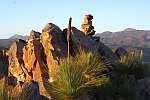
- Subsiduary peaks Terere and Sendeyo loom above the Mackinder Valley as the track passes the Lower Simba Tarn - Mt Kenya
-
eggs - Lagarostrobos franklinii
- Posts: 10479
- Joined: Fri 23 May, 2008 2:58 pm
- Location: Para Vista, South Australia
- Region: South Australia
Re: Game: Where-is-it? (international)
![]() by jrg » Tue 24 Jul, 2018 10:04 pm
by jrg » Tue 24 Jul, 2018 10:04 pm
- jrg
- Nothofagus gunnii

- Posts: 43
- Joined: Sat 05 May, 2012 5:47 pm
- Region: New South Wales
Re: Game: Where-is-it? (international)
![]() by eggs » Wed 25 Jul, 2018 9:45 am
by eggs » Wed 25 Jul, 2018 9:45 am
-
eggs - Lagarostrobos franklinii
- Posts: 10479
- Joined: Fri 23 May, 2008 2:58 pm
- Location: Para Vista, South Australia
- Region: South Australia
Re: Game: Where-is-it? (international)
![]() by GregR » Wed 25 Jul, 2018 10:29 am
by GregR » Wed 25 Jul, 2018 10:29 am
-
GregR - Phyllocladus aspleniifolius

- Posts: 873
- Joined: Mon 07 Jan, 2013 11:24 am
- Region: Victoria
- Gender: Male
Re: Game: Where-is-it? (international)
![]() by eggs » Wed 25 Jul, 2018 11:32 am
by eggs » Wed 25 Jul, 2018 11:32 am
Unless you had been to Mt Kenya or studied the limited maps I could find, it would be hard to say much more than Mt Kenya.
Mt Kenya is a highly eroded/glaciated volcanic peak. It is almost directly on the Equator and has glaciers.
There are 7 U shaped valleys radiating off the sides of the mountain and numerous tarns.
We approached on the Sirimon route via Liki North and exited via the Naro Moru route.
There are at least 10 craggy peaks in the summit area [and more interesting crags on the radiating ridgelines]- but trekkers climb to the 3rd highest - Point Lenana at 4985m (16,355 feet)
Because of altitude, you take your time getting up. Our walk was over 6 days and we were on top for sunrise on day 4.
This was taken on the summit day when we took a long route back to our base at Shiptons Camp.
We descended the ridge off track to the Tooth and traversed the Summit Circuit pass to Simba Col before descending past Lower Simba Tarn to Shiptons Camp.
-
eggs - Lagarostrobos franklinii
- Posts: 10479
- Joined: Fri 23 May, 2008 2:58 pm
- Location: Para Vista, South Australia
- Region: South Australia
Re: Game: Where-is-it? (international)
![]() by jrg » Thu 26 Jul, 2018 11:00 pm
by jrg » Thu 26 Jul, 2018 11:00 pm
Ok, here goes. This is in Western Europe.
- jrg
- Nothofagus gunnii
- Posts: 43
- Joined: Sat 05 May, 2012 5:47 pm
- Region: New South Wales
-
eggs - Lagarostrobos franklinii
- Posts: 10479
- Joined: Fri 23 May, 2008 2:58 pm
- Location: Para Vista, South Australia
- Region: South Australia
Re: Game: Where-is-it? (international)
![]() by jrg » Sat 28 Jul, 2018 11:06 am
by jrg » Sat 28 Jul, 2018 11:06 am
eggs wrote:hmmm...… Scotland.... ?
It is not in Scotland (but not a bad guess - it does remind me of Scottish mountains).
- jrg
- Nothofagus gunnii
- Posts: 43
- Joined: Sat 05 May, 2012 5:47 pm
- Region: New South Wales
Re: Game: Where-is-it? (international)
![]() by jrg » Mon 30 Jul, 2018 11:52 pm
by jrg » Mon 30 Jul, 2018 11:52 pm
The mountain which this was taken from has a wall going up to its summit. You can see other parts of the wall on the top RH corner and left top of the photo.
- jrg
- Nothofagus gunnii
- Posts: 43
- Joined: Sat 05 May, 2012 5:47 pm
- Region: New South Wales
Re: Game: Where-is-it? (international)
![]() by GregR » Tue 31 Jul, 2018 7:51 pm
by GregR » Tue 31 Jul, 2018 7:51 pm
-
GregR - Phyllocladus aspleniifolius
- Posts: 873
- Joined: Mon 07 Jan, 2013 11:24 am
- Region: Victoria
- Gender: Male
Re: Game: Where-is-it? (international)
![]() by eggs » Tue 31 Jul, 2018 11:01 pm
by eggs » Tue 31 Jul, 2018 11:01 pm
Can't place anywhere in Lakes District, so tending to think it might be in Snowdownia
-
eggs - Lagarostrobos franklinii
- Posts: 10479
- Joined: Fri 23 May, 2008 2:58 pm
- Location: Para Vista, South Australia
- Region: South Australia
Re: Game: Where-is-it? (international)
![]() by jrg » Thu 02 Aug, 2018 7:58 pm
by jrg » Thu 02 Aug, 2018 7:58 pm
It is not in Snowdonia or Hadrian's Wall.
As another hint, the mountain is in the UK.
- jrg
- Nothofagus gunnii
- Posts: 43
- Joined: Sat 05 May, 2012 5:47 pm
- Region: New South Wales
Re: Game: Where-is-it? (international)
![]() by ribuck » Thu 02 Aug, 2018 9:27 pm
by ribuck » Thu 02 Aug, 2018 9:27 pm
-

ribuck - Athrotaxis selaginoides

- Posts: 1887
- Joined: Wed 15 May, 2013 3:47 am
- Region: Other Country
- Gender: Male
Re: Game: Where-is-it? (international)
![]() by GregR » Fri 03 Aug, 2018 9:27 am
by GregR » Fri 03 Aug, 2018 9:27 am
-
GregR - Phyllocladus aspleniifolius
- Posts: 873
- Joined: Mon 07 Jan, 2013 11:24 am
- Region: Victoria
- Gender: Male
Re: Game: Where-is-it? (international)
![]() by eggs » Fri 03 Aug, 2018 10:38 am
by eggs » Fri 03 Aug, 2018 10:38 am
-
eggs - Lagarostrobos franklinii
- Posts: 10479
- Joined: Fri 23 May, 2008 2:58 pm
- Location: Para Vista, South Australia
- Region: South Australia
Re: Game: Where-is-it? (international)
![]() by jrg » Fri 03 Aug, 2018 8:41 pm
by jrg » Fri 03 Aug, 2018 8:41 pm
GregR wrote:Northern Ireland. Slieve Bearnagh in the Mourne mountains.
Well done. Taken on the way down from the summit of Slieve Donard. It was very cold up there that day (about -6º!)
- jrg
- Nothofagus gunnii
- Posts: 43
- Joined: Sat 05 May, 2012 5:47 pm
- Region: New South Wales
Re: Game: Where-is-it? (international)
![]() by GregR » Sat 04 Aug, 2018 9:44 pm
by GregR » Sat 04 Aug, 2018 9:44 pm
- Attachments
-
-
GregR - Phyllocladus aspleniifolius
- Posts: 873
- Joined: Mon 07 Jan, 2013 11:24 am
- Region: Victoria
- Gender: Male
-
eggs - Lagarostrobos franklinii
- Posts: 10479
- Joined: Fri 23 May, 2008 2:58 pm
- Location: Para Vista, South Australia
- Region: South Australia
Re: Game: Where-is-it? (international)
![]() by GregR » Sat 04 Aug, 2018 10:38 pm
by GregR » Sat 04 Aug, 2018 10:38 pm
eggs wrote:Loughrigg Fell?
No need for the question mark Eggs, it absolutely is Loughrigg Fell, a little gem.
Over the Eggs yet again.
-
GregR - Phyllocladus aspleniifolius
- Posts: 873
- Joined: Mon 07 Jan, 2013 11:24 am
- Region: Victoria
- Gender: Male
Re: Game: Where-is-it? (international)
![]() by eggs » Sun 05 Aug, 2018 11:09 pm
by eggs » Sun 05 Aug, 2018 11:09 pm
- At the Kirkstone of Kirkstone Pass in the Lakes District - looking North to Brothers Waters & Place Fell
-
eggs - Lagarostrobos franklinii
- Posts: 10479
- Joined: Fri 23 May, 2008 2:58 pm
- Location: Para Vista, South Australia
- Region: South Australia
Re: Game: Where-is-it? (international)
![]() by eggs » Mon 06 Aug, 2018 2:30 pm
by eggs » Mon 06 Aug, 2018 2:30 pm
-
eggs - Lagarostrobos franklinii
- Posts: 10479
- Joined: Fri 23 May, 2008 2:58 pm
- Location: Para Vista, South Australia
- Region: South Australia
Re: Game: Where-is-it? (international)
![]() by johnw » Mon 06 Aug, 2018 3:49 pm
by johnw » Mon 06 Aug, 2018 3:49 pm
eggs wrote:I'm looking for the name of the Pass, and I think the rock in view is something to do with it.
I can sort of match it to Kirkstone Pass, Lakes District.
In Nature's keeping they are safe, but through the agency of man destruction is making rapid progress - John Muir c1912
-
johnw - Lagarostrobos franklinii
- Posts: 9075
- Joined: Wed 23 Jan, 2008 11:59 am
- Location: Macarthur Region - SW Sydney
- Region: New South Wales
- Gender: Male
Return to Games and Competitions
Who is online
Users browsing this forum: No registered users and 17 guests