Hi gang
Has anybody walked into Colo Meroo campground from Upper Colo Rd Recently? I want an easy walk in campsite far away to be quiet free of hoardes of car campers.
I understand access is through private property..
is access still possible from Upper Col Rd? I have phones Richmond NPWS, left a message for reply.
Thanks in advance
Jack
Colo Meroo campsite
Forum rules
NSW & ACT specific bushwalking discussion. Please avoid publishing details of access to sensitive areas with no tracks.
NSW & ACT specific bushwalking discussion. Please avoid publishing details of access to sensitive areas with no tracks.
15 posts
• Page 1 of 1
Colo Meroo campsite
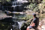
![]() by jackattack » Wed 03 Jul, 2019 1:11 pm
by jackattack » Wed 03 Jul, 2019 1:11 pm
- jackattack
- Athrotaxis cupressoides

- Posts: 125
- Joined: Sat 27 Jun, 2015 9:24 am
- Region: New South Wales
- Gender: Male
Re: Colo Meroo campsite
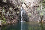
![]() by Rosscodj » Fri 05 Jul, 2019 9:17 am
by Rosscodj » Fri 05 Jul, 2019 9:17 am
https://www.nationalparks.nsw.gov.au/ca ... sitor-info
From the NPWS website (link above):
I'd say it's still ok to go via that route.
Looks like a nice spot! I'll have to check it out once day.
From the NPWS website (link above):
Alternatively, if starting upstream from Upper Colo Road:
This 2.5km walking track crosses private property so please leave the gates as you find them
Please ensure you stay on the marked walking route into Colo Meroo
I'd say it's still ok to go via that route.
Looks like a nice spot! I'll have to check it out once day.
-
Rosscodj - Athrotaxis cupressoides
- Posts: 109
- Joined: Tue 30 Sep, 2014 3:57 pm
- Location: Newcastle, NSW
- Region: New South Wales
- Gender: Male
Re: Colo Meroo campsite
![]() by jackattack » Fri 05 Jul, 2019 1:15 pm
by jackattack » Fri 05 Jul, 2019 1:15 pm
Yeah I read that as well. I drove out on Wednesday night to take a look. The sign on gate clearly stated No river access. There was a barking dog and a light came on and I retreated before I could nose around more.
I will follow up with NPWS and report.
Jack
I will follow up with NPWS and report.
Jack
- jackattack
- Athrotaxis cupressoides
- Posts: 125
- Joined: Sat 27 Jun, 2015 9:24 am
- Region: New South Wales
- Gender: Male
Re: Colo Meroo campsite
![]() by rcaffin » Fri 05 Jul, 2019 8:44 pm
by rcaffin » Fri 05 Jul, 2019 8:44 pm
Yes, you can walk in to the NPWS Colo Meroo camp site - always.
The 4WD track is meant to be on a gazetted public right of way, but it sometimes wanders off the theoretical route. That does not matter however, as the law gives you the right to walk the track even if it strays. So says the Chief Engineer for Colo Shire in his official capacity. Just stay on the track.
The gate at the start is locked, and it will stay that way. It keeps the trail bikes and 4WDs out, and no-one wants to change that (no-one that matters, anyhow). It's an easy walk.
The 'No River Access' sign applies to the properties along the way. Once you leave the track (before getting to the campground) you are trespassing on Private Property, so don't. You can however access the river at the Colo Meroo campground, legally.
Yes, ALWAYS leave any gates as you find them.
Cheers
Roger
-

rcaffin - Athrotaxis selaginoides

- Posts: 1238
- Joined: Thu 17 Jul, 2008 3:46 pm
Re: Colo Meroo campsite
![]() by jackattack » Sat 06 Jul, 2019 7:13 pm
by jackattack » Sat 06 Jul, 2019 7:13 pm
Hi Rodger,
Thankyou for this information. I will walk in this way
soon and have a quiet relaxing time by the
river.
I agree gates should be shut to 4wd and motorbikes.
And yes to respect of gates.
I really appreciate your advice, I was
disappointed when I thought I couldn't walk in.
Thankyou! Jack
Thankyou for this information. I will walk in this way
soon and have a quiet relaxing time by the
river.
I agree gates should be shut to 4wd and motorbikes.
And yes to respect of gates.
I really appreciate your advice, I was
disappointed when I thought I couldn't walk in.
Thankyou! Jack
- jackattack
- Athrotaxis cupressoides
- Posts: 125
- Joined: Sat 27 Jun, 2015 9:24 am
- Region: New South Wales
- Gender: Male
Re: Colo Meroo campsite
![]() by Tortoise » Sat 06 Jul, 2019 7:55 pm
by Tortoise » Sat 06 Jul, 2019 7:55 pm
Great news! The easy access to Meroo brings back fantastic memories. It was my first overnighter after 2 years totally out of the bush with chronic fatigue. A bunch of friends helped carry my stuff. We had a cuppa on the way, and I needed a couple of lie-down rests. We had 3 magical days in there. In spite of the amazing remote multi-days I've done since then, it still counts as one of my best walks ever! 
-

Tortoise - Lagarostrobos franklinii

- Posts: 5177
- Joined: Sat 28 Jan, 2012 9:31 pm
- Location: NW Tasmania
- Region: Tasmania
- Gender: Female
Re: Colo Meroo campsite
![]() by rcaffin » Sun 07 Jul, 2019 12:45 pm
by rcaffin » Sun 07 Jul, 2019 12:45 pm
When you get to the Colo-Meroo campground, you can go up to Meroo itself. A bit of a steep climb, but not too far. At the 'top' there are two tracks. The one on the right goes to Mt Lagoon (longish) via a narrow rocky ridge and then across the plateau. The one on the left goes to the Meroo trig. There is room for a couple of tents up there somewhere, but (obviously) no water.
Cheers
Roger
Cheers
Roger
-
rcaffin - Athrotaxis selaginoides
- Posts: 1238
- Joined: Thu 17 Jul, 2008 3:46 pm
Re: Colo Meroo campsite
![]() by johnw » Sun 07 Jul, 2019 2:34 pm
by johnw » Sun 07 Jul, 2019 2:34 pm
rcaffin wrote:The one on the right goes to Mt Lagoon (longish) via a narrow rocky ridge and then across the plateau.
Mailes Ridge - Has some fantastic views in places looking down on the Colo R. I remember years ago doing an overnight trip this way to Colo Meroo. We shared the campsite with a large wombat that huffed at us then went about its business. Lovely spot.
John W
In Nature's keeping they are safe, but through the agency of man destruction is making rapid progress - John Muir c1912
In Nature's keeping they are safe, but through the agency of man destruction is making rapid progress - John Muir c1912
-

johnw - Lagarostrobos franklinii
- Posts: 9162
- Joined: Wed 23 Jan, 2008 11:59 am
- Location: Macarthur Region - SW Sydney
- Region: New South Wales
- Gender: Male
Re: Colo Meroo campsite
![]() by Neo » Sun 07 Jul, 2019 5:26 pm
by Neo » Sun 07 Jul, 2019 5:26 pm
A great spot is Bob Turners Track. Go over the bridge, up the hill and past the roadhouse a few hundred metres turn left for about 1km. It's a nice walk down to the river, a bit upstream of Meroo. Could pitch there but on the other side is a great beach for sand camping and swimming. No toilet.
I hope to explore much further upstream one day, Colo Gorge.
I hope to explore much further upstream one day, Colo Gorge.
- Neo
- Athrotaxis selaginoides
- Posts: 1888
- Joined: Wed 31 Aug, 2016 4:53 pm
- Location: Port Macquarie NSW
- Region: New South Wales
- Gender: Male
Re: Colo Meroo campsite
![]() by Petew » Tue 20 Aug, 2019 1:50 pm
by Petew » Tue 20 Aug, 2019 1:50 pm
Colo gorge is wonderful. I haven't been there for years but did maybe 5 week long trips there on lilos in the late 80s and early 90s. Great way to spend a week.
- Petew
- Phyllocladus aspleniifolius

- Posts: 711
- Joined: Wed 05 Oct, 2016 12:07 pm
- Region: New South Wales
- Gender: Male
Re: Colo Meroo campsite
![]() by mandragara » Mon 26 Aug, 2019 7:57 pm
by mandragara » Mon 26 Aug, 2019 7:57 pm
I go to the Colo quite regularly, never been south of Bob Turners though, maybe I should investigate the T3 track - Colo Meroo loop sometime. You lot have tempted me.
-
mandragara - Athrotaxis cupressoides
- Posts: 128
- Joined: Fri 22 Dec, 2017 5:04 pm
- Location: Sydney
- Region: New South Wales
- Gender: Male
Re: Colo Meroo campsite
![]() by Neo » Mon 26 Aug, 2019 8:11 pm
by Neo » Mon 26 Aug, 2019 8:11 pm
Waratahs grow around there. Very tall and narrow.
Once off tracked downstream of Bobs, crossed to a beach, the T3 sounds familiar. Camped up high then ended at Meroo.
Once off tracked downstream of Bobs, crossed to a beach, the T3 sounds familiar. Camped up high then ended at Meroo.
- Neo
- Athrotaxis selaginoides
- Posts: 1888
- Joined: Wed 31 Aug, 2016 4:53 pm
- Location: Port Macquarie NSW
- Region: New South Wales
- Gender: Male
Re: Colo Meroo campsite
![]() by rcaffin » Tue 27 Aug, 2019 8:51 pm
by rcaffin » Tue 27 Aug, 2019 8:51 pm
maybe I should investigate the T3 track - Colo Meroo loop sometime.
Mt Lagoon - T3 - Colo - Colo-Meroo camp - Mt Meroo - Mt Lagoon is a very long day even in summer time. As an overnight, camping at Colo-Meroo, it should be easy.
The river banks are pretty thick in places. We found the fastest way down the river was by walking in it. Pick a low water level for this.
You can do a shorter loop by going up the steep narrow spur opposite the S end of the Townsend spur (left side of gully going up). However, there are some cliffs, and a bit of rope or tape is strongly recommended. Having a rock climber with you is helpful. Be careful.
Cheers
Roger
-
rcaffin - Athrotaxis selaginoides
- Posts: 1238
- Joined: Thu 17 Jul, 2008 3:46 pm
Re: Colo Meroo campsite
![]() by mandragara » Sat 31 Aug, 2019 8:21 pm
by mandragara » Sat 31 Aug, 2019 8:21 pm
Cheers for the info.
I'm one of those start at dawn, finish after dark daywalkers, so I think I'll be OK. I might get clever and dump my mtn bike at the firetrail above Meroo so I can ride back to my car at T3 track!
I'm one of those start at dawn, finish after dark daywalkers, so I think I'll be OK. I might get clever and dump my mtn bike at the firetrail above Meroo so I can ride back to my car at T3 track!
-
mandragara - Athrotaxis cupressoides
- Posts: 128
- Joined: Fri 22 Dec, 2017 5:04 pm
- Location: Sydney
- Region: New South Wales
- Gender: Male
Re: Colo Meroo campsite
![]() by Wollemi » Wed 24 Jun, 2020 12:01 pm
by Wollemi » Wed 24 Jun, 2020 12:01 pm
rcaffin wrote:When you get to the Colo-Meroo campground, you can go up to Meroo itself. A bit of a steep climb, but not too far. At the 'top' there are two tracks. The one on the right goes to Mt Lagoon (longish) via a narrow rocky ridge and then across the plateau. The one on the left goes to the Meroo trig. There is room for a couple of tents up there somewhere, but (obviously) no water.
I would like to travel a loop; Upper Colo - Colo Meroo - Maile's Ridge - Gospers Ridge - Sam's Way - Mountain Lagoon Trail - Comleroy Road.
The issue of concern is I want to do the trip by CX bike + is the 4km of apparently steep ridge defined well at the moment ? I have not travelled Maile's Ridge or Gosper's Ridge before.
It is likely I may go alone - is the navigation to find the start at the bottom in Colo Meroo tricky ? I won't have a GPS.
I will swap out of my SPD shoes into runners early on to carry the large bicycle. I have previously walked in and out of the T3 track alone (but then got lost in heavy rain while walking out with 2 others)
EDIT. 26/06. Trip done, carrying a fixie. 32km from Upper Colo. Colo Meroo access was confusing + I passed through three gates that said no trespassing, but no-one came out of two different houses to challenge me as I walked through properties. Sign there guides you to Mailes Ridge walking track. Took 7 hrs to do this loop via Sam's Way. The Mailes Ridge track was indistinct at times, taking up much precious daylight. Gosper's Ridge trail has soil berms caused by trail-bikes
Live everyday as if it were your last... one day you will be right.
- Wollemi
- Athrotaxis cupressoides
- Posts: 275
- Joined: Tue 24 Jul, 2012 10:32 am
- Location: lower Blue Mts
- Region: New South Wales
- Gender: Male
15 posts
• Page 1 of 1
Return to New South Wales & ACT
Who is online
Users browsing this forum: No registered users and 2 guests