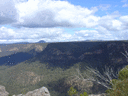
Thought I'd take advantage of the burnt understorey on the weekend, and do a loop from the Wattle Ridge car park, down to Rocky Waterholes Creek, downstream to the Nattai, then back up Starlights. Skirting the boundary of Wattle Ridge after the turkey nest dam brings you to a distinct fire trail heading away from the property's southern boundary. Some of the fences are gone following the fire, but the track is pretty obvious on Google Earth to give some insight into where you're headed. If you hit a gully with a drainage line from a small dam you've gone too far. There's an indistinct track off to the left just after you enter the fire trail. This will get you where you're going, but is not nearly as interesting. If you follow the cleared trail (thankyou Wattle Ridge) until just after the cleared section ends you arrive at a left hand turn which takes you across the adjacent gully. As you walk down the slope you reach a broad stone shelf with a collection of rock features reminiscent of Drawing Room Rocks. The track then runs along the base of a low stone ridge on the far side of the gully. There's an interesting erosion feature just above the track where you hit the stone ridge, then at the other end of the ridge is a really good potential camp cave. A little further along is another left turn that takes you down an old switchback to Rocky Waterholes Creek, which is also quite obvious on Google Earth.
I have no idea why this road would have been built, unless they thought there was gold in the creek. It's badly eroded now, but is a seriously impressive bit of engineering that basically goes nowhere. Just upstream of the end of the road is an impressive rock overhang, festooned with stalactites. Walking dowstream to the apex of the oxbow visible on the maps is fairly straightforward, and brings you to a lovely rock platform with braided channels of water running through it. Really nice spot. A little further downstream is a short waterfall running into a perfect swimming hole. The water felt about five degrees, so I gave it a miss. After this the character of the valley changes completely - for the next couple of kilometres it is a constant scramble over and around fallen rocks and boulders. Very slow and very taxing, but also some lovely spots with impressive cliffs and rockforms above. Fair to say that I was well and truly knackered by the time I got close to the Nattai. At this point there is now effectively a broad sandy delta at the confluence of the two streams, but if you stay on the bench above the right hand bank of the creek you eventually find yourself above the Nattai. The weed infestations on the benches have made them a fairly unpleasant walk unfortunately. From here its a straightforward walk along the river to Emmett's Flat, although i did have the unnerving experience of walking into quicksand in front of Macarthur's Flat. Only went up to my knee, but it was quite disconcerting. The whole day took me ten hours, although a younger, fitter walker could do it a fair bit quicker I imagine.
Rocky Watewrholes Creek
Forum rules
Posting large/multiple images in this forum is OK. Please start topic titles with the name of the location or track.
For topics focussed on photos rather than the trip, please consider posting in the 'Gallery' forum instead.
This forum is for posting information about trips you have done, not for requesting information about a track or area.
8 posts
• Page 1 of 1
Rocky Watewrholes Creek
![]() by Hughmac » Mon 31 Aug, 2020 8:22 pm
by Hughmac » Mon 31 Aug, 2020 8:22 pm
- Hughmac
- Athrotaxis cupressoides

- Posts: 154
- Joined: Sat 14 Apr, 2012 9:20 pm
- Region: New South Wales
Re: Rocky Watewrholes Creek
![]() by puredingo » Tue 01 Sep, 2020 8:40 am
by puredingo » Tue 01 Sep, 2020 8:40 am
G’day Hugh great report mate, sounds vigorous to say the least.
I was in the Nattai over the weekend too, it’s a shame I didn’t bump you. Perhaps you seen my Ute in the car park?
You’re right, the weeds are back with a vengeance and so, unfortunately, are the pigs.
I was in the Nattai over the weekend too, it’s a shame I didn’t bump you. Perhaps you seen my Ute in the car park?
You’re right, the weeds are back with a vengeance and so, unfortunately, are the pigs.
- puredingo
- Athrotaxis selaginoides

- Posts: 1267
- Joined: Mon 13 Feb, 2012 6:54 am
- Region: New South Wales
Re: Rocky Watewrholes Creek
![]() by michael_p » Tue 01 Sep, 2020 9:09 am
by michael_p » Tue 01 Sep, 2020 9:09 am
Hughmac wrote:There's an indistinct track off to the left just after you enter the fire trail. This will get you where you're going, but is not nearly as interesting. If you follow the cleared trail (thankyou Wattle Ridge) until just after the cleared section ends you arrive at a left hand turn which takes you across the adjacent gully. As you walk down the slope you reach a broad stone shelf with a collection of rock features reminiscent of Drawing Room Rocks. The track then runs along the base of a low stone ridge on the far side of the gully.
The track off to the left is the Dome Rock track. Yes, it is not that interesting but it does get you there. I didn't stop to have a good look at that broad stone shelf as I was walking uphill not downhill at the time
Hughmac wrote:A little further along is another left turn that takes you down an old switchback to Rocky Waterholes Creek, which is also quite obvious on Google Earth.
Did you have any trouble getting down to the creek from the end of that track? Reason I ask is the information I have is that ropes are required to get down the last bit.
Middle section of Rocky Wateholes Ck sounds nice, I will have to add it to my very long list of walks to do.
Cheers,
Michael.
One foot in front of the other.
-
michael_p - Athrotaxis selaginoides
- Posts: 1378
- Joined: Sun 15 Nov, 2009 6:58 pm
- Location: Macarthur Region of Sydney.
- Region: New South Wales
- Gender: Male
Re: Rocky Watewrholes Creek
![]() by Hughmac » Tue 01 Sep, 2020 7:51 pm
by Hughmac » Tue 01 Sep, 2020 7:51 pm
Cheers Aaron, I actually noticed the ute there and wondered if it was yours! Busy place on Saturday - got back to the carpark at 6.30, and there were still ten cars there.
Hi Michael - no ropes required if you find the old road, no more difficult than the last stretch of Starlights.
Hi Michael - no ropes required if you find the old road, no more difficult than the last stretch of Starlights.
- Hughmac
- Athrotaxis cupressoides
- Posts: 154
- Joined: Sat 14 Apr, 2012 9:20 pm
- Region: New South Wales
Re: Rocky Watewrholes Creek
![]() by puredingo » Tue 01 Sep, 2020 9:21 pm
by puredingo » Tue 01 Sep, 2020 9:21 pm
Busy spot of late although nobody where I was. I pioneered my own way up onto the Wangenderry tableland, did some exploring, camped up for the night but couldn’t remember where my new pass was the next day!!! so bashed my way down to Beloon pass.
- puredingo
- Athrotaxis selaginoides
- Posts: 1267
- Joined: Mon 13 Feb, 2012 6:54 am
- Region: New South Wales
Re: Rocky Watewrholes Creek
![]() by Hughmac » Thu 03 Sep, 2020 6:33 pm
by Hughmac » Thu 03 Sep, 2020 6:33 pm
I guess the fires would have helped you get across to Beloon. How did you approach Wanganderry? From the Alum valley?
- Hughmac
- Athrotaxis cupressoides
- Posts: 154
- Joined: Sat 14 Apr, 2012 9:20 pm
- Region: New South Wales
Re: Rocky Watewrholes Creek
![]() by puredingo » Thu 03 Sep, 2020 7:37 pm
by puredingo » Thu 03 Sep, 2020 7:37 pm
Yeah mate, I just started off from Allum flat (which as far as good camping goes, is no more) and headed N/E until I was up under the sheer face, found a small tumbledown break in the walls and up I went. I could probably get out the map and give you a GR if you wanted one.
Although the fires went through it was way tougher going than I expected bashing the 4 or 5 klms back to Beloon, which made me give thanks I’d not gone with my original plan to go the other way back to Bonnum pic.
That was 3x’s further!!
Although the fires went through it was way tougher going than I expected bashing the 4 or 5 klms back to Beloon, which made me give thanks I’d not gone with my original plan to go the other way back to Bonnum pic.
That was 3x’s further!!
- puredingo
- Athrotaxis selaginoides
- Posts: 1267
- Joined: Mon 13 Feb, 2012 6:54 am
- Region: New South Wales
Re: Rocky Watewrholes Creek
![]() by Hughmac » Mon 07 Sep, 2020 7:53 pm
by Hughmac » Mon 07 Sep, 2020 7:53 pm
Thanks, but my next sojourn will probably down Martins Creek to Nattai Rd then back around to carpark. Need to get myself 'walk' fit - haven't had a suitable vehicle to get anywhere off a main road for 18 months, so the legs and shoulders need a bit of work.
- Hughmac
- Athrotaxis cupressoides
- Posts: 154
- Joined: Sat 14 Apr, 2012 9:20 pm
- Region: New South Wales
8 posts
• Page 1 of 1
Return to NSW & ACT Trip Reports & Track Notes
Who is online
Users browsing this forum: No registered users and 7 guests