Myself and some friends are looking at doing Clumner Bluff in about two weeks time.
I have heard that the route has changed quite a bit recently during to logging and was just wondering if anyone had done this walk recently and could give me a bit of a route description especially with notes on where to start the walk.
Cheers,
Michael.
Clumner Bluff
Forum rules
Tasmania specific bushwalking discussion. Please avoid publishing details of access to sensitive areas with no tracks.
Tasmania specific bushwalking discussion. Please avoid publishing details of access to sensitive areas with no tracks.
5 posts
• Page 1 of 1
Clumner Bluff
![]() by MichaelP » Sun 18 Jul, 2010 10:01 pm
by MichaelP » Sun 18 Jul, 2010 10:01 pm
-
MichaelP - Atherosperma moschatum

- Posts: 96
- Joined: Fri 03 Jul, 2009 3:14 pm
- Location: From Launceston, currently studying in Melbourne
- Region: Victoria
- Gender: Male
Re: Clumner Bluff
![]() by tastrekker » Mon 19 Jul, 2010 9:27 am
by tastrekker » Mon 19 Jul, 2010 9:27 am
G'day MichaelP,
Check out my blog entry at http://www.blognow.com.au/tastrekker/ (you will have to click next page a couple of times to find the story - the direct link has stopped working for some reason). It was written after the start of the track was logged. However, there has been a bushfire on that coupe since then so conditions may have changed again.
Here's a cut and paste of the relevant paragraphs from the blog.
Regards,
TasTrekker
This time I took the normal track from the logging road Clumner Spur 1. The notes in "The Abels" and this trip report on "Wild Tiger" say look out for the cairn beside the road after 2.2km as it can be hard to spot. Things have changed! The start of the track has been logged!
From the obvious cairn beside the road, cairns lead the way along the now-well-established snig tracks until the upper extent of recent logging is reached. At this point, watch out for cairns on the left as the track heads onto a very old logging track which soon peters out completely.
Cairns and tapes lead the way through scrubby bush where the track is quite difficult to follow at ground level. There has not been enough traffic to clear moss and leaves. The tree line is abruptly reached at the foot of a steep scree slope. Again, the lack of traffic means route finding is up to you with occasional caurns only giving a general direction to follow.
-

tastrekker - Athrotaxis cupressoides

- Posts: 499
- Joined: Thu 20 Sep, 2007 9:04 pm
- Location: Lenah Valley
- Region: Tasmania
- Gender: Male
Re: Clumner Bluff
![]() by MichaelP » Mon 19 Jul, 2010 1:56 pm
by MichaelP » Mon 19 Jul, 2010 1:56 pm
Cheers tastrekker,
Just clarifying, is the 'obvious cairn' at the start still about 2.2 kms along the road? or in a totally different spot?
Thanks
Just clarifying, is the 'obvious cairn' at the start still about 2.2 kms along the road? or in a totally different spot?
Thanks
-
MichaelP - Atherosperma moschatum
- Posts: 96
- Joined: Fri 03 Jul, 2009 3:14 pm
- Location: From Launceston, currently studying in Melbourne
- Region: Victoria
- Gender: Male
Re: Clumner Bluff
![]() by JamesMc » Mon 19 Jul, 2010 7:46 pm
by JamesMc » Mon 19 Jul, 2010 7:46 pm
You want to take Shannon's Pad. See
http://tastracks.webs.com/merseyvalley.htm#488722016
for details
JamesMc
http://tastracks.webs.com/merseyvalley.htm#488722016
for details
JamesMc
- JamesMc
- Athrotaxis cupressoides
- Posts: 322
- Joined: Wed 09 Dec, 2009 5:24 pm
- Region: Victoria
- Gender: Male
Re: Clumner Bluff
![]() by wello » Mon 19 Jul, 2010 10:51 pm
by wello » Mon 19 Jul, 2010 10:51 pm
This is a top walk and highly recommended.
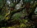
I found the start of the track using Tas Trekker's notes, but it's one you could easily miss if you're not looking carefully. The photo shows the cairn.
When I was there in Dec 09, there was a parking space on the side of the road finished in grey gravel contrasting to the surrounding brown dirt. Bracken ferns were starting to overgrow much of the logging area, although staying on the snig tracks was not difficult (it was very steep initially though!). The tricky bit is identifying where the track leaves the logging area and enters the old growth. A bit of patience is about all I can suggest.
The track is well cairned once you find it, although not obvious to follow due to lack of traffic.
After a while in the forest, you exit onto standard dolerite scree. Its about an hour's worth and not overly well cairned. There's a pole with pink flagging marking the point where the track descends into the bush, which could be quite handy.
There's a few tricky spots to get off the scree onto the plateau, but again nothing a bit of patience won't solve. From there, you can make your own way to the summit across alpine heath (eg scoparia) but generally good going and no scrub bashing required. There's a very substantial cairn (2m tall or so) about 5 minutes walk south of where you hit the plateau, which would make a good marker on the way down.
The view from the top toward the Walls is just excellent. I headed to the eastern edge of the summit block and enjoyed a long lunch in beautiful weather. It would be a dangerous spot if you got clouded in though. There's no track on top, and minimal landmarks. All up, I took 6 hours walking time. Distance is around 8 - 10km, with around 700m of elevation gain.
Again, this is a top walk, very isolated feeling.
Wello
I found the start of the track using Tas Trekker's notes, but it's one you could easily miss if you're not looking carefully. The photo shows the cairn.
- Start of track
When I was there in Dec 09, there was a parking space on the side of the road finished in grey gravel contrasting to the surrounding brown dirt. Bracken ferns were starting to overgrow much of the logging area, although staying on the snig tracks was not difficult (it was very steep initially though!). The tricky bit is identifying where the track leaves the logging area and enters the old growth. A bit of patience is about all I can suggest.
The track is well cairned once you find it, although not obvious to follow due to lack of traffic.
After a while in the forest, you exit onto standard dolerite scree. Its about an hour's worth and not overly well cairned. There's a pole with pink flagging marking the point where the track descends into the bush, which could be quite handy.
There's a few tricky spots to get off the scree onto the plateau, but again nothing a bit of patience won't solve. From there, you can make your own way to the summit across alpine heath (eg scoparia) but generally good going and no scrub bashing required. There's a very substantial cairn (2m tall or so) about 5 minutes walk south of where you hit the plateau, which would make a good marker on the way down.
The view from the top toward the Walls is just excellent. I headed to the eastern edge of the summit block and enjoyed a long lunch in beautiful weather. It would be a dangerous spot if you got clouded in though. There's no track on top, and minimal landmarks. All up, I took 6 hours walking time. Distance is around 8 - 10km, with around 700m of elevation gain.
Again, this is a top walk, very isolated feeling.
Wello
- wello
- Athrotaxis cupressoides
- Posts: 147
- Joined: Sat 05 Apr, 2008 10:43 am
5 posts
• Page 1 of 1
Who is online
Users browsing this forum: No registered users and 50 guests