Hi all,
I've just returned from the Overland track and I'm itching to get back out there, so I'm planning to walk the Tharwa to thredbo section of the aawt.
I have a fair idea of what will be required in terms of physical and mental stamina as well as all the supplies I need. However, I am not overly confident in my orienteering skills. I have chapmans book which I have studied, yet forum posts seem to indicate it is somewhat outdated.
How well marked is this section of the trail? I haven't found a definitive report on this recently. Some recent experience would be lovely.
Also my planned departure date will be in early February. The summer weather is of concern. I am tossing up between carrying 3 or 4 litres of water - I am not sure if the extra kilo or so and reduced space will warrant a need to carry the fourth litre.
Thank you.
Advice needed: AAWT Tharwa to Thredbo
23 posts
• Page 1 of 1
Advice needed: AAWT Tharwa to Thredbo
![]() by josh97 » Sun 21 Jan, 2018 8:47 pm
by josh97 » Sun 21 Jan, 2018 8:47 pm
Last edited by josh97 on Mon 22 Jan, 2018 9:32 am, edited 1 time in total.
- josh97
- Nothofagus cunninghamii

- Posts: 5
- Joined: Sun 21 Jan, 2018 7:20 pm
- Region: Australian Capital Territory
- Gender: Male
Re: Advice needed: AAWT Tharwa to Thredbo
![]() by Lophophaps » Sun 21 Jan, 2018 10:54 pm
by Lophophaps » Sun 21 Jan, 2018 10:54 pm
Josh, welcome to the forum.
John's book is still reasonably accurate. The AAWT is mostly on a track, very easy to follow. Most junctions have a marker, and some have a marker 50 metres along the track. As far as I'm aware the only trackless sections are Port Phillip Trail to the Murrumbidgee River (which has a good track under the phone line and in other places) and over the Viking (also good tracks in a few places). Both these sections will be interesting in low visibility, but with a GPS it should be much easier. In fine weather for the Port Phillip Trail section a GPS is not necessary. This is a pic looking back from the first phone pole to Port Phillip Trail. The blue arrow shows where I left the trail, which is more or less where the red arrow is. The red ellipse shows the on-off foot track to the poles. The other end is similar.
A number of people have done the walk recently, and will be able to give further and better particulars.
-

Lophophaps - Auctorita modica

- Posts: 3383
- Joined: Wed 09 Nov, 2011 9:45 am
- Region: Victoria
- Gender: Male
Re: Advice needed: AAWT Tharwa to Thredbo
![]() by josh97 » Mon 22 Jan, 2018 9:32 am
by josh97 » Mon 22 Jan, 2018 9:32 am
Lophophaps wrote:Josh, welcome to the forum.
John's book is still reasonably accurate. The AAWT is mostly on a track, very easy to follow. Most junctions have a marker, and some have a marker 50 metres along the track. As far as I'm aware the only trackless sections are Port Phillip Trail to the Murrumbidgee River (which has a good track under the phone line and in other places) and over the Viking (also good tracks in a few places). Both these sections will be interesting in low visibility, but with a GPS it should be much easier. In fine weather for the Port Phillip Trail section a GPS is not necessary. This is a pic looking back from the first phone pole to Port Phillip Trail. The blue arrow shows where I left the trail, which is more or less where the red arrow is. The red ellipse shows the on-off foot track to the poles. The other end is similar.
A number of people have done the walk recently, and will be able to give further and better particulars.
Appreciated mate.
- josh97
- Nothofagus cunninghamii
- Posts: 5
- Joined: Sun 21 Jan, 2018 7:20 pm
- Region: Australian Capital Territory
- Gender: Male
Re: Advice needed: AAWT Tharwa to Thredbo
![]() by crollsurf » Mon 22 Jan, 2018 12:39 pm
by crollsurf » Mon 22 Jan, 2018 12:39 pm
Hi Josh,
I did the walk back in November and the book is good unless you want to nitpick. I took a compass and a 1:100,000 topo and never used the topo once. Book and compass worked well for navigation.
Heaps of water around then, probably not as much around now but all those marked in the book should be reliable.
NSW Parks have replaced a lot of signs recently so not a problem in the KNP
Little or no signage in the Cotter Dam catchment.
The shortcut to Happys in very over grown
There is a lot of fire trail walking so go off-track where possible.
A lot of the offtrack descibed in the book is marshy/wet so I kind of wish I had have worn boots to keep my feet dry.
Don't worry if you lose your way off-track, its open country, so not hard to navigate back on track with compass.
Maybe allow extra time and visit Blue Waterholes and Jagungal if your into peak bagging.
November is probably the best time as there is still plenty of snow around from Kiandra to Thredbo. It makes for better scenery but not enough to impede you.
I started from Honeysucklle creek. Tharwa to Honeysuckle is a slog.
-

crollsurf - Lagarostrobos franklinii

- Posts: 2252
- Joined: Tue 07 Mar, 2017 10:07 am
- Location: Sydney
- Region: New South Wales
- Gender: Male
Re: Advice needed: AAWT Tharwa to Thredbo
![]() by DavidB » Mon 22 Jan, 2018 12:58 pm
by DavidB » Mon 22 Jan, 2018 12:58 pm
Endorse what was said earlier.
Chapman provides track updates at http://www.john.chapman.name/aawt-upd.html
Also worth checking this website for general info and updates at https://theaustralianalps.wordpress.com ... ence/aawt/
I did Thredbo to Tharwa in late summer/early autumn nearly 2 years ago. Navigation is pretty straightforward for most of the way. We took a compass bearing after leaving the Murrumbidgee to find the old phone lines - you can pick them up in the distance anyway and I imagine doing it from the north would be just as straightforward.
Do recommend going off-track where the weather allows. And definitely try to take the Rolling Ground and the Main Range to avoid a road bash to Thredbo. Will need a compass for the bit through the Rolling Ground.
In relation to water Chapman is a good guide but we crossed the Brindabellas during a dry spell and water was hard to find in places (apart from the main creeks/rivers). Might have to hunt around for it and be prepared to use water thats a bit dirty (treat it of course). Otherwise carry some extra. Definitely recommend calling in at Blue Waterholes for at least a night (and a dip). And do include some side trips to peaks. The way up to Binberi from Murray Gap is easy to follow (footpad/cairns).
Oh and avoid camping at Honeysuckle Creek on a Friday night. Really noisy with people playing loud music. Might be quieter mid-week.
Have a great trip.
- DavidB
- Atherosperma moschatum

- Posts: 86
- Joined: Tue 11 Oct, 2016 9:06 am
- Region: New South Wales
- Gender: Male
Re: Advice needed: AAWT Tharwa to Thredbo
![]() by Lophophaps » Mon 22 Jan, 2018 1:44 pm
by Lophophaps » Mon 22 Jan, 2018 1:44 pm
The above posts have merit.
Happys shortcut is all but gone. Just go downhill. From Happys go south over the plains to the Dr Phillips Hut Site. There's brumby tracks and the management track is impossible to miss. It's also shorter and has less climbing. From near Mackays Hut there are a number of options. It's possible to go over Jagungal, to Cesjacks, Mawsons, and Gungartan. This is much better than the roadbash to O'Keefes, Grey Mare, Valentine and Schlink. From Schlink Pass go up to Dicky Cooper. From here to the shoulder of Twynum tracks are on-off, but it's easy navigation in fine weather. Water is everywhere, campsites less so. If you have to stop on the Main Range unexpectedly due to weather, get down out of the wind.
If you post your itinerary then we can comment. It will also be possible to advise about campsites that are away from the masses, like the summit of Gungartan.
-
Lophophaps - Auctorita modica
- Posts: 3383
- Joined: Wed 09 Nov, 2011 9:45 am
- Region: Victoria
- Gender: Male
Re: Advice needed: AAWT Tharwa to Thredbo
![]() by josh97 » Mon 22 Jan, 2018 4:49 pm
by josh97 » Mon 22 Jan, 2018 4:49 pm
Thank you all.
It is my time in the bush that makes me appreciate your replies - help from strangers like you who are willing to go out of there way and share their experiences. Society is about helping each other and enjoying life together.
I am planning to set off in a little over a week. I haven't completed an itinerary - I am still working on this as well as factoring in inclement weather emergency detours to huts, but I am planning on putting up a big post when this is all finished.
In terms of navigation I have two primary concerns based off Chapman's book and other posts around here:
1. The track immediately SW of Pond Creek Flats appears to be hard to follow. I cannot locate topos in my nearby stores for these regions.
2. The same concern goes for the wilderness area as the track departs from Port Phillip Trail to Bullock Hill Trail - I can't seem to find the appropriate maps. This section worries me. There is an old fire trail towards the east of this wilderness route that I was planning to take that passes via MIller's Hut, but I am concerned that the state of the trail will be equivalent to a wilderness section.
When you guys mention off track, do you mean taking the alternate routes that don't follow gravel/minor roads? If so I would love to do this, however this is more of a reconnaissance trip. I will be solo and I would rather be on the safer side of things. I am confident in my hiking skills but not overly so that I trust being able to return to the track having ventured far off. I cannot afford the required maps so Chapman's book will be all I have aside from maybe a couple of 1:50 maps. I will not have food drops so I will have to carry my entire load. This greatly restricts my trip so I will not aim to take longer than 2 weeks.
You guys are very helpful. Any more pointers would be great.
Thank you all.
- josh97
- Nothofagus cunninghamii
- Posts: 5
- Joined: Sun 21 Jan, 2018 7:20 pm
- Region: Australian Capital Territory
- Gender: Male
Re: Advice needed: AAWT Tharwa to Thredbo
![]() by bigkev » Mon 22 Jan, 2018 5:41 pm
by bigkev » Mon 22 Jan, 2018 5:41 pm
josh97 wrote:Thank you all.
It is my time in the bush that makes me appreciate your replies - help from strangers like you who are willing to go out of there way and share their experiences. Society is about helping each other and enjoying life together.
I am planning to set off in a little over a week. I haven't completed an itinerary - I am still working on this as well as factoring in inclement weather emergency detours to huts, but I am planning on putting up a big post when this is all finished.
In terms of navigation I have two primary concerns based off Chapman's book and other posts around here:
1. The track immediately SW of Pond Creek Flats appears to be hard to follow. I cannot locate topos in my nearby stores for these regions.
2. The same concern goes for the wilderness area as the track departs from Port Phillip Trail to Bullock Hill Trail - I can't seem to find the appropriate maps. This section worries me. There is an old fire trail towards the east of this wilderness route that I was planning to take that passes via MIller's Hut, but I am concerned that the state of the trail will be equivalent to a wilderness section.
When you guys mention off track, do you mean taking the alternate routes that don't follow gravel/minor roads? If so I would love to do this, however this is more of a reconnaissance trip. I will be solo and I would rather be on the safer side of things. I am confident in my hiking skills but not overly so that I trust being able to return to the track having ventured far off. I cannot afford the required maps so Chapman's book will be all I have aside from maybe a couple of 1:50 maps. I will not have food drops so I will have to carry my entire load. This greatly restricts my trip so I will not aim to take longer than 2 weeks.
You guys are very helpful. Any more pointers would be great.
Thank you all.
Hi Josh,
I walked the AAWT S2N last October/November. I'd agree with everything already stated so won't go over the same ground.
Reading your questions it appears that the navigation is worrying you the most? I carried topo's for any spots that I planned to leave the 'official' route as well as a Rooftop map in case I needed a bigger overview. To be brutally truthful though the only maps I used day to day were Chapman's along with my GPS topo maps. Even through Victoria where the navigation can be tough Chapman's stuff got me through.
The AAWT SW of Pond Creek Flats is no worries, it's a defined track.
As Lophophaps has said the section from Port Phillip Trail to the 'Bidgee probably looks more daunting than it actually is on the ground. Make a way point as you leave Port Phillip Trail and head across towards the old telephone line (it's open rolling grass land, mainly) and that way if by some chance you miss the telegraph line then it will be easy to retrace your way back to Port Phillip Trail and try again. Once you reach the old telegraph line and are ready to head down to the 'Bidgee take another way point. As Lophophaps photo shows the lay of the land largely funnels you in the right direction.
Another section that is a little vague is the walk along the flats beside the Orroral River before you join Cotter Hut Road, if you loose the pad you can fairly easily head SW to intersect with Cotter Hut Road a bit earlier.
If you want to explore around Bimberi, Jagungal or the Main Range off the main route than some navigation skills will be needed, especially if the weather is less than optimal!
One other thing to be aware of that the route isn't always sign posted or way marked as the AAWT (especially in wilderness areas) so you have to keep an eye on the maps as you may be following Murray Gap Trail instead of the AAWT for example (that sentence is little clunky but I'm thinking you'll know what I mean
I'm in the process of writing up a blog of my walk but I've only got the Walhalla to Hotham section online so far so it's not much use to you.
Go for it, it'll be great...
-
bigkev - Athrotaxis cupressoides

- Posts: 444
- Joined: Sat 30 Jun, 2012 6:44 pm
- Region: Victoria
- Gender: Male
Re: Advice needed: AAWT Tharwa to Thredbo
![]() by Lophophaps » Mon 22 Jan, 2018 6:18 pm
by Lophophaps » Mon 22 Jan, 2018 6:18 pm
While I was working on some words Kev replied. We duplicate!
Not much time for a major jaunt like this.
I was puzzled at Pond Creek Flats. In fact I surged down from Cotter Gap - which has gritty water a tad hard to access - and just followed the 4WD track. Water here: tank up at Sawpit Creek, should be reliable, and get the next water at Pond Creek Flats. Then just before the road at the ford. A few creeks on the way up to the border.
I read somewhere that the track south from Millers Hut is scrubby. Someone may be able to clarify this. The walk to the pole lines took me 40 minutes, and I was going slow. I'm old, over 25. In fine weather it is not hard as you can see the poles. At the south end take care not to walk off it. Bear left down a gully on an open slope. It's all open here. There's an on-off track from the saddle due north of the Murrumbidgee crossing, about 1.2 kilometres away.
When I say on-off track I mean that the track comes and goes. Often by following a logical line you will pick up the next bit. By off track we mean going where there is no track. For the AAWT this generally means open plains. For example, if you go to O'Keefes hut then walk a bit further to a weather station then up to Jagungal where the track peters out at the top. From here go east on the summit ridge then south to a major north-south ridge that heads towards Mawsons Hut. Two river crossings, and a track for the last 15 minutes to Mawsons.
From Mawsons go south onto the Kerries, no track. Just up and keep high, making sure you keep going south and not SW, as this leads to Schlink Hilton. Pick up water and find Gungartan, lovely shelter.
If you get bushed, attempt to hit a line at right angles. A line may be a river, creek, road, foot track or fence. Then follow the line to where you should be or a known point. This technique is called a handrail. A good place to try this is at Happys Hut. At Tabletop Trail go a few minutes past Boltons Trail then head south. It's scrubby but you will emerge into a plain in 30-40 minutes. The scrub-plain boundary is a line. You are now near Happys Hut, and just cast around for it. There's a 4WD track that goes to the hut, another line. Find the 4WD track and turn right. It may seem hard and you may have serious doubts but it's all in the mind.
From the hut go on the 4WD track for a short distance until you an head south across the plain to the power lines.
It seems to me that you lack navigational confidence, and this is normal. Just start easy and be careful. If the weather is rubbish or you are tired, stop, wait, find another way.
This is the saddle 1.2 km north of the Murrumbidgee. The red line shows roughly where I went, and the ellipse is vaguely near Witzes
The tent about 100 metres from Happys Hut looking east. The 4WD track is more obvious than it seems. I came down the slope behind and to my left.
Looking back at the hut. The arrow shows where the ridge roads are located. I came out near the red line. My actual route is unclear.
-
Lophophaps - Auctorita modica
- Posts: 3383
- Joined: Wed 09 Nov, 2011 9:45 am
- Region: Victoria
- Gender: Male
Re: Advice needed: AAWT Tharwa to Thredbo
![]() by GBW » Mon 22 Jan, 2018 6:39 pm
by GBW » Mon 22 Jan, 2018 6:39 pm
Agree with everything said. Did this in March 2016 over 16 days. Used Chapmans book and a couple of Rooftop maps, no problems.
There are many side trips and alternative routes (some off track) so if you allow extra time you can do most of them. Highlights for me were Booroomba Rocks, Bimberi, Blue Waterholes, Tabletop, Brooks Hut, Jagungal, Mawsons Hut, Gungartan, Townsend, Rolling Ground, Ramshead Range. We didn't stray far from the 'official' route apart from the Main Range and a few "shortcuts" but spent some time exploring the surrounding area.
Plenty of water except Witzes Hut.
I went a bit overboard with food drops at Blue Waterholes, Kiandra and Dershkos Hut (used the push bike from Round Mountain). Yarrangobilly caves is worth a look also.
Read Chapmans book, carry a map/compass/gps you should be right. Have fun.
"If you wish to make an apple pie from scratch, you must first invent the universe"
-
GBW - Athrotaxis selaginoides

- Posts: 1181
- Joined: Fri 02 May, 2014 9:03 am
- Location: Melbourne
- Region: Victoria
- Gender: Male
Re: Advice needed: AAWT Tharwa to Thredbo
![]() by crollsurf » Mon 22 Jan, 2018 6:43 pm
by crollsurf » Mon 22 Jan, 2018 6:43 pm
Off-track I'm referring to the alternate routes in the book. I just did 1 food drop at Kiandra
With the fear of overloading you with info, regarding the Port Phillip Trail to Murrumbidgee River and finding the phone poles. I wouldn't get too hung up on that. We overshot the poles and ended up with a splendid view overlooking Dairymans Creek. From there you should be able to see the saddle. There is a ridge between you and the saddle. Just traverse around to the ridge and head for the saddle. Once you reach the saddle, a track will appear a little way down the saddle, which heads a little to the left to what I was expecting. Just follow the track and your nose and you will be right.
The weather could be more of an issue than navigation. You'll probably bump into a few trout fishers from Blue Waterhole to Kiandra, who will happily give you an update. If you think you will be out of power after Kiandra, maybe take a trannie. If it's looking like bad weather on the Main Range, follow the official route from Schlinks, otherwise follow the suggested off-track route in the book. Hope you get good weather for that because its the highlight of the walk.
-
crollsurf - Lagarostrobos franklinii
- Posts: 2252
- Joined: Tue 07 Mar, 2017 10:07 am
- Location: Sydney
- Region: New South Wales
- Gender: Male
Re: Advice needed: AAWT Tharwa to Thredbo
![]() by josh97 » Mon 22 Jan, 2018 8:05 pm
by josh97 » Mon 22 Jan, 2018 8:05 pm
Thanks again all.
Yes I will be one of those trout fishermen. Im bringing a light tackle set up - 6wt rod/reel, a fly box and some leader and tippet.
Thank you for your advice. I will try and tackle these sections in good visibility. Whilst I am quite experienced with treks like these in solitude, it occurred to me that I've always really known where I'm going, so Ill make sure the weather is good here with escape routes planned and relevant topos on hand.
More questions sure to come, but I thank you all extensively, this really does help me a lot!
- josh97
- Nothofagus cunninghamii
- Posts: 5
- Joined: Sun 21 Jan, 2018 7:20 pm
- Region: Australian Capital Territory
- Gender: Male
Re: Advice needed: AAWT Tharwa to Thredbo
![]() by Lophophaps » Tue 23 Jan, 2018 5:55 am
by Lophophaps » Tue 23 Jan, 2018 5:55 am
crollsurf wrote:If you think you will be out of power after Kiandra, maybe take a trannie.
Like this:
- Trannie and day walkers.jpg (43.71 KiB) Viewed 40271 times
-
Lophophaps - Auctorita modica
- Posts: 3383
- Joined: Wed 09 Nov, 2011 9:45 am
- Region: Victoria
- Gender: Male
Re: Advice needed: AAWT Tharwa to Thredbo
![]() by josh97 » Tue 23 Jan, 2018 9:30 pm
by josh97 » Tue 23 Jan, 2018 9:30 pm
Lophophaps wrote:It seems to me that you lack navigational confidence, and this is normal. Just start easy and be careful. If the weather is rubbish or you are tired, stop, wait, find another way.
Mate, further investigation of the map has made me worried about the Rolling Grounds sections. The Main Range and Murrumbidgee sections shouldn't be too bad, but the Rolling Grounds looks like a pretty barren, land-mark free 8km stretch of the trail. I've got the topos, but Chapman's book is a bit ambiguous about these sections. I know how it runs, especially in terrain like this; it all makes sense at home tucked in a warm bed with a cup of tea studying the maps but when you're out there and everything looks the same is when the problems arise. Minimal foot pads and tracks, I don't really want to be following a compass bearing for this long. Any advice/photos for this section? It's really worrying me.
- josh97
- Nothofagus cunninghamii
- Posts: 5
- Joined: Sun 21 Jan, 2018 7:20 pm
- Region: Australian Capital Territory
- Gender: Male
Re: Advice needed: AAWT Tharwa to Thredbo
![]() by Zapruda » Wed 24 Jan, 2018 5:28 am
by Zapruda » Wed 24 Jan, 2018 5:28 am
The Rolling grounds in fine weather is easy, in bad weather it is horrible and we all know that bad weather is as likely as good up there.
By the sounds of it your navigational abilities aren’t up to scratch and you should consider the other people that will need to come looking for you if things don’t work out.
Learn how navigate with a compass. 90% of the time you won’t need it but when you do you will be thankful.
By the sounds of it your navigational abilities aren’t up to scratch and you should consider the other people that will need to come looking for you if things don’t work out.
Learn how navigate with a compass. 90% of the time you won’t need it but when you do you will be thankful.
-
Zapruda - Athrotaxis selaginoides
- Posts: 1690
- Joined: Thu 07 Apr, 2016 10:46 am
- Region: Australian Capital Territory
- Gender: Male
Re: Advice needed: AAWT Tharwa to Thredbo
![]() by Lophophaps » Wed 24 Jan, 2018 8:29 am
by Lophophaps » Wed 24 Jan, 2018 8:29 am
Josh, Zapruda and I are saying the same thing. Most people who have been up there a few times will agree with us. In fine weather it's easy, in clag it is not. With a GPS it's a lot easier. Break the journey into small sections, like this.
From Schlink Pass go SW to pick up the ridge, which curves to NW and then west. Best not to go west from the pass as this leads to steep and rocks. After maybe 30 minutes the edge of the summit plateau is reached. This is a good place for a rest. From here there's no more steep bits – it's done for the next few hours. Go west over the plateau to the Dicky Cooper ridge. It took me just under an hour to get from Schlink Pass to the DCB ridge, including a rest on the edge of the plateau.
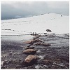
From the DCB ridge go southish, slowly descending into a broad saddle. Aim for a big isolated rock block, maybe 10 metres square. The pic of the snow drifts is about halfway from DCB to the big rock. Keep above the creek until you are in the broad saddle, then go to the rock. From here go southish and gently up. Continue southish an gently up to the summit, which is more or less a bump. This is the blue arrow.
Southish and gently down until you can see the ridge curving to the west (to your right) a short distance in front. I usually cut this corner, have a short drink at the creek, gently up the other side. More southish. Consett Stephen Pass will now be in view, with the Tate north ridge and Tate behind. When you can, cut the corner, SW to above CSP. There's a track for the last bit.
Down to CSP and up the other side. It's important to go all the way to the top of the Tate Ridge. There are a number of contour tracks to the south (left) as you ascend to the ridge. These go onto steep ground and there's a steep climb to get to Tate at the end of the contour tracks, so go to the ridge. There's an on-off track here, just find the easiest way to Tate. The snowdrift pic shows the ridge route to Tate, which is the yellow arrow. Twynum is the red arrow. Allow about 3 hours from the pic to Tate, including rests.
There's a flat mostly sheltered campsite just south of Tate, water down a short steep distance.
Break the Rolling ground into legs: Pass – DCB – big rock – summit – south on the ridge – cut corner get water - south – cut corner to CSP – up to Tate Ridge – south to Tate. It will take 4-5 hours to get from Schlink Pass to Tate. I've done it summer and winter, no GPS.
Here's a few pics.
Rolling Ground near Dicky Cooper Bogong looking south. Big rock in circle, RG high point blue arrow, Tate yellow arrow
Rolling Ground
Tate campsite
From Schlink Pass go SW to pick up the ridge, which curves to NW and then west. Best not to go west from the pass as this leads to steep and rocks. After maybe 30 minutes the edge of the summit plateau is reached. This is a good place for a rest. From here there's no more steep bits – it's done for the next few hours. Go west over the plateau to the Dicky Cooper ridge. It took me just under an hour to get from Schlink Pass to the DCB ridge, including a rest on the edge of the plateau.
From the DCB ridge go southish, slowly descending into a broad saddle. Aim for a big isolated rock block, maybe 10 metres square. The pic of the snow drifts is about halfway from DCB to the big rock. Keep above the creek until you are in the broad saddle, then go to the rock. From here go southish and gently up. Continue southish an gently up to the summit, which is more or less a bump. This is the blue arrow.
Southish and gently down until you can see the ridge curving to the west (to your right) a short distance in front. I usually cut this corner, have a short drink at the creek, gently up the other side. More southish. Consett Stephen Pass will now be in view, with the Tate north ridge and Tate behind. When you can, cut the corner, SW to above CSP. There's a track for the last bit.
Down to CSP and up the other side. It's important to go all the way to the top of the Tate Ridge. There are a number of contour tracks to the south (left) as you ascend to the ridge. These go onto steep ground and there's a steep climb to get to Tate at the end of the contour tracks, so go to the ridge. There's an on-off track here, just find the easiest way to Tate. The snowdrift pic shows the ridge route to Tate, which is the yellow arrow. Twynum is the red arrow. Allow about 3 hours from the pic to Tate, including rests.
There's a flat mostly sheltered campsite just south of Tate, water down a short steep distance.
Break the Rolling ground into legs: Pass – DCB – big rock – summit – south on the ridge – cut corner get water - south – cut corner to CSP – up to Tate Ridge – south to Tate. It will take 4-5 hours to get from Schlink Pass to Tate. I've done it summer and winter, no GPS.
Here's a few pics.
Rolling Ground near Dicky Cooper Bogong looking south. Big rock in circle, RG high point blue arrow, Tate yellow arrow
Rolling Ground
Tate campsite
- 11595 Tate camp.png (812.03 KiB) Viewed 40173 times
-
Lophophaps - Auctorita modica
- Posts: 3383
- Joined: Wed 09 Nov, 2011 9:45 am
- Region: Victoria
- Gender: Male
Re: Advice needed: AAWT Tharwa to Thredbo
![]() by paidal_chalne_vala » Thu 29 Mar, 2018 6:04 pm
by paidal_chalne_vala » Thu 29 Mar, 2018 6:04 pm
After camping at Mt. Tate how do you get back to Guthega Power station?
Do you push on towards the Illawong hut and cross the Snowy River at the Suspension bridge? Isn't there some thick knee high scrub that way ?
That is way longer than following the Schlink track back to the Guthega Power station.
Do you push on towards the Illawong hut and cross the Snowy River at the Suspension bridge? Isn't there some thick knee high scrub that way ?
That is way longer than following the Schlink track back to the Guthega Power station.
- paidal_chalne_vala
- Lagarostrobos franklinii
- Posts: 2470
- Joined: Sun 22 Jan, 2012 10:30 pm
- ASSOCIATED ORGANISATIONS: VNPA.BTAC.Friends of Baw Baw.Mt.Bogong Club.
- Region: Victoria
- Gender: Male
Re: Advice needed: AAWT Tharwa to Thredbo
![]() by Zapruda » Thu 29 Mar, 2018 6:37 pm
by Zapruda » Thu 29 Mar, 2018 6:37 pm
If your goal is to head back to Guthega power station then the Illawong footpad is not really an option unless you want to walk on the road. Remember there is Guthega (the resort/township/Dam) then there is the Guthega Power station.
Heading back to GPS from Tate is easy in good weather. You drop down to Consett Stephens Pass then go cross county over the Rolling Grounds to the "Granite Peaks" and from there you will pick up a footpad down to Whites River hut.
The Schlink corridor is pretty boring and uninspiring. I would be Starting at Guthega Dam and head up to Guthega trig - Rolling Grounds - White River - Gungarten - The Kerries - Mawsons - Bluff Tarn - Jagungal - Grey Mare hut - Valentines - Dicky cooper - Rolling Grounds - Tate - Twynam - Pounds Creek - Illawong track - Guthega.
This would take a few days though. let me know if you want me to draw a map or offer any other suggestions.
Cheers
Last edited by Zapruda on Tue 03 Apr, 2018 8:00 pm, edited 1 time in total.
-
Zapruda - Athrotaxis selaginoides
- Posts: 1690
- Joined: Thu 07 Apr, 2016 10:46 am
- Region: Australian Capital Territory
- Gender: Male
Re: Advice needed: AAWT Tharwa to Thredbo
![]() by Zapruda » Thu 29 Mar, 2018 7:02 pm
by Zapruda » Thu 29 Mar, 2018 7:02 pm
paidal_chalne_vala wrote:Isn't there some thick knee high scrub that way?
There is waist high scrub before the bridge coming from Guthega but it doesn’t encroach on the track.
Now, coming down to Whites River from the Rolling grounds is a different story. I think of it as full body exfoliation. Same came be said for a good chunk of Jagungal off track...
-
Zapruda - Athrotaxis selaginoides
- Posts: 1690
- Joined: Thu 07 Apr, 2016 10:46 am
- Region: Australian Capital Territory
- Gender: Male
Re: Advice needed: AAWT Tharwa to Thredbo
![]() by paidal_chalne_vala » Tue 03 Apr, 2018 7:40 pm
by paidal_chalne_vala » Tue 03 Apr, 2018 7:40 pm
I just walked this route over Easter: GPS- Disappointment spur hut/ White's River Hut/Schlink Pass/ Schlink Hut/ Valentine's hut on Easter Sat. and returned to Horse camp Hut on Easter Sunday and walked out yesterday to the GPS.
I will have a crack at walking the Rolling ground next Green season so I can XC ski it the year after.
I will have a crack at walking the Rolling ground next Green season so I can XC ski it the year after.
- paidal_chalne_vala
- Lagarostrobos franklinii
- Posts: 2470
- Joined: Sun 22 Jan, 2012 10:30 pm
- ASSOCIATED ORGANISATIONS: VNPA.BTAC.Friends of Baw Baw.Mt.Bogong Club.
- Region: Victoria
- Gender: Male
Re: Advice needed: AAWT Tharwa to Thredbo
![]() by Lophophaps » Wed 11 Apr, 2018 8:49 pm
by Lophophaps » Wed 11 Apr, 2018 8:49 pm
The pad from the Rolling Ground to Whites River may be hard to follow in either direction. Another way is to go from Consett Stephen Pass SE or so to the top of the pensocks, then down steeply, or pick up the bends on the road above Guthega PS. There's an article describing this in the April magazine.
-
Lophophaps - Auctorita modica
- Posts: 3383
- Joined: Wed 09 Nov, 2011 9:45 am
- Region: Victoria
- Gender: Male
Re: Advice needed: AAWT Tharwa to Thredbo
![]() by Zapruda » Thu 12 Apr, 2018 6:59 am
by Zapruda » Thu 12 Apr, 2018 6:59 am
Lophophaps wrote:The pad from the Rolling Ground to Whites River may be hard to follow in either direction. Another way is to go from Consett Stephen Pass SE or so to the top of the pensocks, then down steeply, or pick up the bends on the road above Guthega PS. There's an article describing this in the April magazine.
In the interest of keeping info up to date, I walked the pad in both directions last month and it was easy to follow from just below the Granite peaks as well as from the hut.
I am going to try your other suggestions one day, Lop.
Cheers.
-
Zapruda - Athrotaxis selaginoides
- Posts: 1690
- Joined: Thu 07 Apr, 2016 10:46 am
- Region: Australian Capital Territory
- Gender: Male
Re: Advice needed: AAWT Tharwa to Thredbo
![]() by Lophophaps » Thu 12 Apr, 2018 9:50 am
by Lophophaps » Thu 12 Apr, 2018 9:50 am
Zapruda, thanks for the update on the pad-track. This is quite useful information, and varies to the advice I had. Did you like my typo, pensocks? This is not a pen that will write on socks. It's a big series of tubes with water inside, going to Guthega PS.
-
Lophophaps - Auctorita modica
- Posts: 3383
- Joined: Wed 09 Nov, 2011 9:45 am
- Region: Victoria
- Gender: Male
23 posts
• Page 1 of 1
Who is online
Users browsing this forum: No registered users and 1 guest