I am heading down to Tassie next week to do a four shorter walks (2-4 days) to see a few places that have eluded me over the years. A couple of them have off track sections I would like to get a bit more information about. Any input would be welcome. Please pm about the off track questions.
I plan to do a loop from Wombat Moor, Lake Belton, Tyenna Peak, Mt Field West, Newdegate Pass, Tarn Shelf, Wombat Moor. Two questions:
1. I gather it is easier to go up from Belton to Tyenna Peak than find a route down. Any clues as to the best route, just the line of least resistance from the southern end of Belton or up the micro ridge a bit further north, something else?
2. What is the condition of the hut on the path to Lake Belcher?
I also plan to do a loop from Lake St Clair over Rufus, Hugel, Little Hugel.
1. How problematic are the boulders on the south side of Hugel? I assume from what I have read this is the main issue, if not what other issues might I face?
2. Is the little tarn shown in the Rufus-Hugel saddle a reliable water source?
A couple of questions, Mt Field & Rufus-Hugel
Forum rules
Tasmania specific bushwalking discussion. Please avoid publishing details of access to sensitive areas with no tracks.
Tasmania specific bushwalking discussion. Please avoid publishing details of access to sensitive areas with no tracks.
8 posts
• Page 1 of 1
A couple of questions, Mt Field & Rufus-Hugel
![]() by Mark F » Mon 30 Jan, 2017 11:07 am
by Mark F » Mon 30 Jan, 2017 11:07 am
"Perfection is attained not when there is nothing more to add, but when there is nothing more to remove".
-

Mark F - Lagarostrobos franklinii

- Posts: 2301
- Joined: Mon 19 Sep, 2011 8:14 pm
- Region: Australian Capital Territory
- Gender: Male
Re: A couple of questions, Mt Field & Rufus-Hugel
![]() by gayet » Mon 30 Jan, 2017 11:34 am
by gayet » Mon 30 Jan, 2017 11:34 am
I can't comment on all your questions but in relation to #2 - if you are referring to Lake Belcher Hut, this may provide some information:
http://fieldfriends.blogspot.com.au/2017/01/lake-belcher-hut-reapir.html
http://fieldfriends.blogspot.com.au/2017/01/lake-belcher-hut-reapir.html
- gayet
- Phyllocladus aspleniifolius

- Posts: 952
- Joined: Sat 12 Feb, 2011 8:01 pm
- Location: Wallan
- Region: Victoria
- Gender: Female
Re: A couple of questions, Mt Field & Rufus-Hugel
![]() by pazzar » Mon 30 Jan, 2017 1:30 pm
by pazzar » Mon 30 Jan, 2017 1:30 pm
1 - The route up Tyenna from Belton is a bit scrubby. Try and find a scree field and use that to get to the top, otherwise you will be pushing through a lot of bauera. From the summit of Tyenna it is mostly open or on boulders the whole way back to K-Col to head to Field West. I don't know much on the hut condition though. It wasn't very inviting the last time I was there, but that was 7 years ago.
2 - The water in the Rufus-Hugel saddle is very reliable. It is quite a large tarn. The boulder field isn't too bad, you just need to negotiate some large-ish boulders up near the summit. in good weather it is pretty clear how to get around them though. If you follow the general SE bearing you should be able to follow boulders the whole way to the bottom. As you get further down they become smaller, so loose rocks are more common. Take care with your ankles!
2 - The water in the Rufus-Hugel saddle is very reliable. It is quite a large tarn. The boulder field isn't too bad, you just need to negotiate some large-ish boulders up near the summit. in good weather it is pretty clear how to get around them though. If you follow the general SE bearing you should be able to follow boulders the whole way to the bottom. As you get further down they become smaller, so loose rocks are more common. Take care with your ankles!
"It's not what you look at that matters, it's what you see."
-
pazzar - Lagarostrobos franklinii
- Posts: 2657
- Joined: Thu 09 Jul, 2009 5:22 pm
- Location: Hobart
- Region: Tasmania
- Gender: Male
Re: A couple of questions, Mt Field & Rufus-Hugel
![]() by bluewombat » Mon 30 Jan, 2017 3:48 pm
by bluewombat » Mon 30 Jan, 2017 3:48 pm
Just a couple of comments which might assist. It is pretty easy to just trend up to Tyenna Peak from the southern end of Belton, as pazzar says there are some scrubby patches but using a few rocks you can avoid the worst of it. There are some lovely tarns on the shelf between Tyenna and Florentine if you are looking for somewhere to spend the night. The hut used to be a wreck but looking at the photos linked to the site gayet put up it looks lovely after being restored. If you do come down to the hut it is possible to walk north up the valley and then climb up to KCol, I seem to recall the pad is on the eastern side of the valley head (I really think the walk along the Tyenna Florentine shelf is nicer). The bog around the track from the Humbolt river to Belcher (and that includes the turn off to Belton area) is pretty horrid at times . It eases after the Belcher hut.
cheers
BW
cheers
BW
Even a long life is short
HPB
HPB
-

bluewombat - Athrotaxis cupressoides

- Posts: 367
- Joined: Sun 10 Feb, 2008 3:55 pm
- Region: Tasmania
Re: A couple of questions, Mt Field & Rufus-Hugel
![]() by north-north-west » Mon 30 Jan, 2017 4:39 pm
by north-north-west » Mon 30 Jan, 2017 4:39 pm
Only scrub I had on Tyenna was from the track to the scree - an hour at most of mild stuff and then it's basically boulder hopping. Don't try to go directly from Tyenna's summit towards Florentine - descend a little back towards the Bel lakes and then sidle. Lots of camping options, from the tarns below Florentine to Petersens, to Clemes Tarn, to Naturalist and Field West plateau. It's a marvellous area.
The camping and water between Rufus and Hugel aren't at the high point of the saddle but just below it to the south. Best tent sites are on a dry hump just above the tarn. There are pads heading from the far side of the tarn up. As has been said, the boulder field is mostly common-sensical. Also good camping by the tarn on the little plateau out towards Little Hugel.
The camping and water between Rufus and Hugel aren't at the high point of the saddle but just below it to the south. Best tent sites are on a dry hump just above the tarn. There are pads heading from the far side of the tarn up. As has been said, the boulder field is mostly common-sensical. Also good camping by the tarn on the little plateau out towards Little Hugel.
"Mit der Dummheit kämpfen Götter selbst vergebens."
-

north-north-west - Lagarostrobos franklinii
- Posts: 15494
- Joined: Thu 14 May, 2009 7:36 pm
- Location: The Asylum
- ASSOCIATED ORGANISATIONS: Social Misfits Anonymous
- Region: Tasmania
-

Tortoise - Lagarostrobos franklinii
- Posts: 5343
- Joined: Sat 28 Jan, 2012 9:31 pm
- Location: NW Tasmania
- Region: Tasmania
- Gender: Female
Re: A couple of questions, Mt Field & Rufus-Hugel
![]() by Mark F » Tue 31 Jan, 2017 10:55 am
by Mark F » Tue 31 Jan, 2017 10:55 am
Thanks all for your input. Now I just need some decent weather. It is great to learn of all the good work being done at Mt Field.
"Perfection is attained not when there is nothing more to add, but when there is nothing more to remove".
-
Mark F - Lagarostrobos franklinii
- Posts: 2301
- Joined: Mon 19 Sep, 2011 8:14 pm
- Region: Australian Capital Territory
- Gender: Male
Re: A couple of questions, Mt Field & Rufus-Hugel
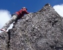
![]() by DanR » Tue 31 Jan, 2017 10:58 am
by DanR » Tue 31 Jan, 2017 10:58 am
Rufus to Hugel
I have just come back from doing the boulder traverse on Sunday from Hugel down to the base of Rufus. For me, this was not a good time but totally doable. We came from Hugel down, where as you will be going up.
There is a low level scrub bash from the track near the base of Rufus, down to the tarn (Nice spot for a camp there), over a creek and up a more scrubby (about shoulder height) slope before you come to the base of the boulder field, as you go up, the boulder get larger.
At a guess the traverse took our group, me being the slowest through the boulder field, about 2.5-3 hours. We spent a bit of time finding our way down from the summit of Hugel down to the ridge line and possibly made life harder for ourselves on this part (not sure if we missed a far easier way down to the ridge, I doubt we could have gotten up the way we came down). Closer to rufus there are parts of the ridge that are like a knife edge with steep slopes and drops on either side, if you're like me and don't like heights, I'd suggesting thinking carefully about taking this route. Lots of boulder hopping and scrambling. You'll probably be using your hands as much as your legs, I scratched up my hands pretty badly and wished I'd had a pair of gardening gloves, like a few of the others.
Once you're on Hugel's summit, the track up, which you'll be coming down was steep but clear and marked with cairns.
Walking back over the ridge toward little Hugel was pretty easy with a bit a pad and some cairns to follow. We stayed on the ridge until we came to the saddle over looking a large tarn and lots of cushion grass (and little hugel in the distance), there is a clear track down to the edge of the tarn at the edge closest to Rufus. We camped next to tarn for an evening. The track from the tarn to Little Hugel was very clear and can be picked up by walking in the direction of Shadow lake. If this track is anything to go by, the walk from here down to shadow lake should be nice and easy.
Hope that helps,
Dan
-

DanR - Nothofagus gunnii

- Posts: 32
- Joined: Mon 01 Aug, 2016 10:10 pm
- Location: Hobart
- Region: Tasmania
- Gender: Male
8 posts
• Page 1 of 1
Who is online
Users browsing this forum: No registered users and 32 guests