Otford to Figure Eight Pools Circuit
Dharawal Country

5 h 15 min to 6 h

13.7 km
circuit

↑ 582 m
↓ -582 m

Hard track
Exploring the southern coast of Royal National Park, this walk experiences different trails and environments, with dense forest at Palm Forest to the open grasslands along the Coastline. With a short side trip out to the Figure Eight Pools, this walk becomes a great day in the bush. The views from the Burgh Ridge are something special, with views far into the distance along the coast. (Check the tide and wave heights, to avoid disappointment at the rock platform for Figure Eight Pools.) Let us begin by acknowledging the Dharawal people, Traditional Custodians of the land on which we travel today, and pay our respects to their Elders past and present. 
Show all
Otford Railway Station. | Photo by admin, 2007.
The view of the Coast from just south of the Werrong Beach Intersection. | Photo by admin, 2007.
Through the palm jungle. | Photo by admin, 2007.
The view of the coast from the grasslands south of Burning Palms Beach. | Photo by admin, 2007.
The sign at the southern end of Burning Palms Beach. | Photo by admin, 2007.
Going through a boulder field. | Photo by admin
A view along the coast from Figure of 8 Pools Track. | Photo by admin
The Coast. | Photo by admin
Figure Eight Pools. | Photo by admin, 2008.
The metal footpath behind Burning Palms Beach. | Photo by admin, 2007.
The sign at Burgh Ridge Track (sth). | Photo by admin, 2007.
The Burgh Ridge Track as it goes away from the coast. | Photo by admin, 2007.
The view of the coast from Burgh Ridge (Nth) Int. | Photo by admin, 2007.
The Garawarra Management. | Photo by admin, 2007.
The occassional view from the Garawarra Management Trail. | Photo by admin, 2007.
Downloads GPX PDF

+
-
Safer Bushwalks
Tips on staying safe on track
Before you start any bushwalk ensure you;
• Tell someone you trust where you are going and what to do if you are overdue
• Have adequate equipment, supplies, skills & knowledge for the whole journey
• Consider the impact of weather forecasts, park/track closures & fire dangers
• Can respond to emergencies & call for help at any point
• Are healthy and fit enough for this journey
If not, change plans and stay safe. It is okay to delay and ask people for help.
+
-
Getting There
Transport options and directions
Start (-34.2107139,151.0054735)
Mode Car (There is free parking available.) Train
DirectionsFrom
  • Turn on to Princes Highway then drive for 580 m
  • At roundabout, take exit 2 onto Parkes Street and drive for another 390 m
  • Turn right onto Cemetery Road and drive for another 520 m
  • Turn left onto Boswell Street and drive for another 65 m
  • Turn right onto McLerie Street and drive for another 190 m
  • Turn right onto Handley Street and drive for another 80 m
  • Turn left onto Walker Street and drive for another 45 m
  • Turn right onto Tabratong Road and drive for another 215 m
  • Turn right onto Otford Road and drive for another 2.3 km
  • Turn sharp left onto Lady Carrington Road and drive for another 420 m
  • Turn slight right and drive for another 150 m
+
-
Track Notes
Turn by turn instructions & maps
Getting started
From the top of Otford Station, this walk follows the signs to 'Royal National Park' up some stairs. Once at the top of the stairs, the walk turns left and climbs up the steep concrete path for approximately 50m to the top, where it comes to the intersection marked as 'Station Rd'. This walk turns left and follows the flat dirt road, passing an intersection with another road on the left. The walk continues along to the next intersection, where it turns right onto Fanshawe Rd. This walk follows Fanshawe Rd up the long hill until coming to an intersection with an asphalt road signposted as 'Lady Wakehurst Drive'. At the intersection, this walk turns left and crosses the road, continuing for approximately 25m until coming to a car park and the entry into Royal National Park. There is a large green sign here saying 'Otford Lookout'.....
Turn map Directions & comments
Start.
There is water tap (about 15 m back from the start).
There is a car park (about 5 m back from the start).
After another 40 m head up the steps (about 10 m long)
Then cross the bridge (about 15 m long)
Then head down the steps (about 15 m long)
After another 15 m head down the steps (about 70 m long)
After another 25 m turn left, to head along Ramp.
After another 75 m (at the intersection of Beaumont Road & Station Road Fire Trail) turn left, to head along Station Road Fire Trail.
After another 215 m (at the intersection of Station Road Fire Trail & Lady Carrington Road) continue straight, to head along Fanshawe Road.
After another 220 m continue straight, to head along Fanshawe Road.
After another 80 m (at the intersection of Lady Wakehurst Drive & Fanshawe Road) turn left, to head along Lady Wakehurst Drive (a road).
After another 255 m find the "Otford Lookout" (on your right).
Otford Lookout
Otford Lookout

Otford Lookout is on the Lady Wakehurst Dr, Otford. The lookout is in the Southern Tip of Royal National Park. The Lookout is on the side of the road with some parking. There are no facilities, but there is a great view out to see and down south down the coast to Wollongong. There is a small grass clearing on the ocean side of the road.
+
-
Otford Lookout is on the Lady Wakehurst Dr, Otford. The lookout is in the Southern Tip of Royal National Park. The Lookout is on the side of the road with some parking. There are no facilities, but there is a great view out to see and down south down the coast to Wollongong. There is a small grass clearing on the ocean side of the road.

Then pass the park (9 m on your right).
Turn right.
After another 50 m pass the sign (on your right).
After another 250 m (at the intersection of Werrong Beach Track & Cliff Track) veer left, to head along Cliff Track.
After another 30 m pass the "Werrong Beach Track" (on your right).
After another 1.5 km turn right.
After another 40 m pass the "Garrawarra Ridge" (8 m on your right).
After another 400 m continue straight.
After another 30 m come to the "Werrong Lookout" (25 m on your right).
After another 1.7 km pass the "Track closed for regeneration" (8 m on your right).
After another 610 m cross the bridge (about 7 m long)
After another 80 m continue straight.
After another 160 m turn right.
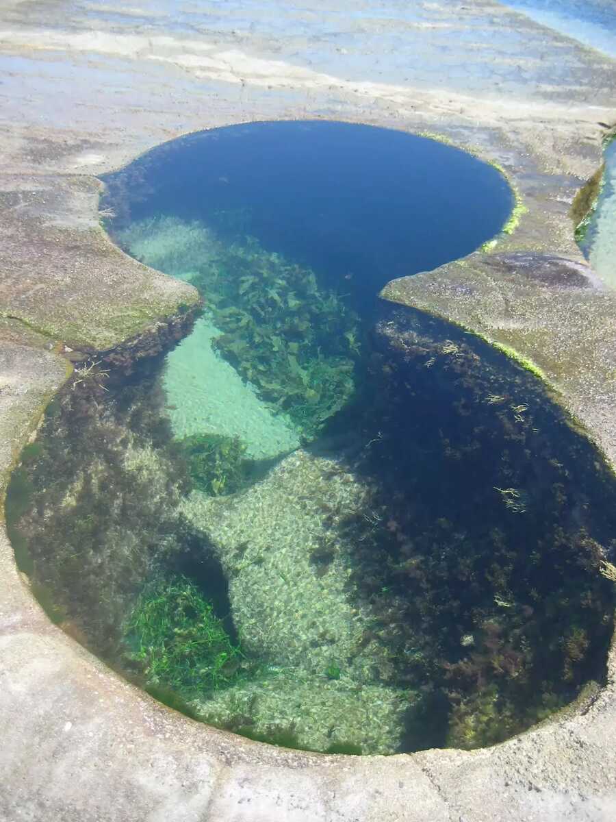
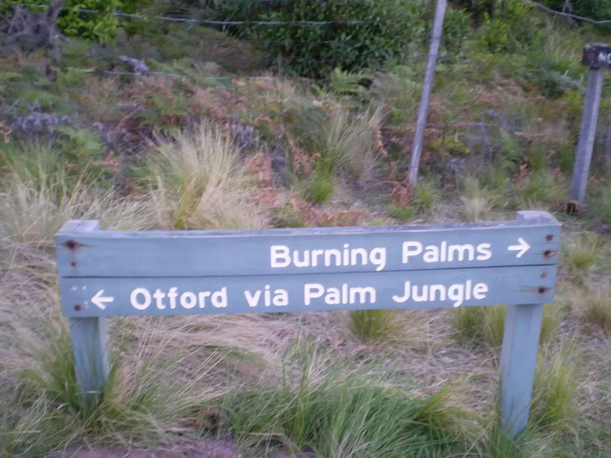
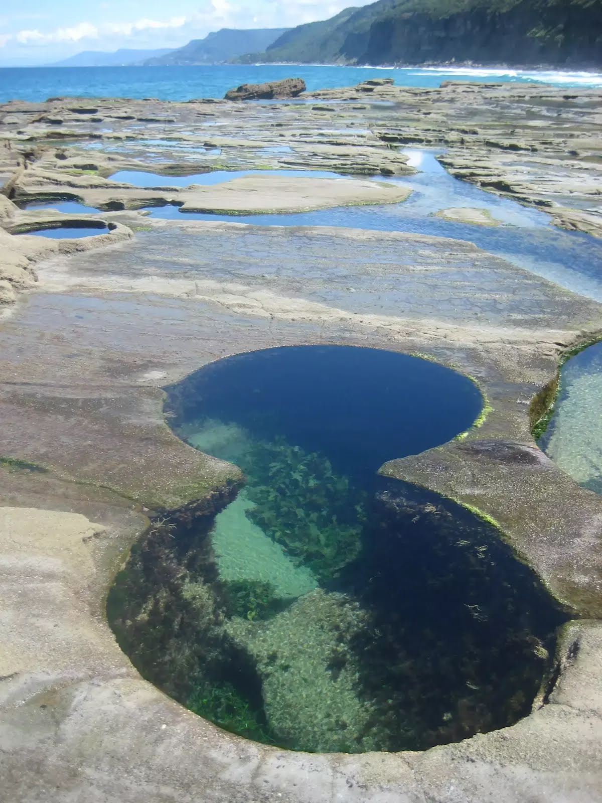
The starting point of an optional sidetrip. An optional side trip to Figure 8 Pools. To start this optional side trip continue straight here. On returning from this side trip turn right when you get back to this intersection. Details below.
After another 65 m veer left.
After another 325 m turn right.
After another 115 m continue straight.
After another 75 m cross the bridge (about 15 m long)
After another 75 m head up the earthen steps (about 140 m long)
After another 25 m veer left, to head along Burgh Ridge Track.
After another 30 m pass the "Burgh Ridge" (on your right).
After another 180 m (at the intersection of Coast Walk & Burgh Ridge Track) turn left, to head along Burgh Ridge Track.
After another 7 m come to the viewpoint.
After another 8 m pass the "Figure 8 Pools" (on your left).
After another 265 m come to the viewpoint.
After another 530 m continue straight, to head along Burgh Ridge Track.
After another 280 m (at the intersection of Garawarra Ridge Management Trail & Burgh Ridge Track) veer left, to head along Garawarra Ridge Management Trail (a vehicle track).
After another 85 m continue straight, to head along Garawarra Ridge Management Trail.
After another 1.2 km continue straight, to head along Garawarra Ridge Management Trail.
After another 1.4 km (at the intersection of Garawarra Ridge Management Trail & Lilyvale Track) continue straight, to head along Garawarra Ridge Management Trail.
After another 370 m continue straight, to head along Garawarra Ridge Management Trail.
After another 1.5 km (at the intersection of Cliff Track & Werrong Beach Track) veer right, to head along Cliff Track.
After another 305 m turn left, to head along Lady Wakehurst Drive.
After another 145 m (at the intersection of Fanshawe Road & Lady Wakehurst Drive) turn right, to head along Fanshawe Road (a vehicle track).
After another 80 m continue straight, to head along Fanshawe Road.
After another 220 m (at the intersection of Station Road Fire Trail & Lady Carrington Road) continue straight, to head along Station Road Fire Trail.
After another 215 m (at the intersection of Beaumont Road & Station Road Fire Trail) turn right, to head along Beaumont Road.
After another 75 m turn right.
After another 25 m head up the steps (about 70 m long)
After another 15 m head up the steps (about 15 m long)
Then cross the bridge (about 15 m long)
Then head down the steps (about 10 m long)
After another 50 m come to the end.

An optional side trip to Figure 8 Pools.
Turn map Directions & comments
Start.
Continue another 950 m to find Figure of Eight Pools at the end.
About 30 m past the end is "Figure Eight Pools".
Figure Eight Pools
Figure Eight Pools

The Figure Eight Pools are on the rock shelf, south of Figure Eight Pools gully, near Burning Palms. There are a number of circular sinkholes in the rock, and a few of them have joined over time to form a figure '8' shape. Two sink holes in particular have joined to form a very spectacular figure '8' shape in the rock. The safest time to visit the pools is at low tide when there is only a very low swell in the ocean.
+
-
The Figure Eight Pools are on the rock shelf, south of Figure Eight Pools gully, near Burning Palms. There are a number of circular sinkholes in the rock, and a few of them have joined over time to form a figure '8' shape. Two sink holes in particular have joined to form a very spectacular figure '8' shape in the rock. The safest time to visit the pools is at low tide when there is only a very low swell in the ocean.

Turn around and retrace your steps back the 950 m to the main route.
+
-
Terrain
Know the Hills, grading & facilities

Otford to Figure Eight Pools Circuit


Grading
Class 4/6
Hard track
Length 13.7 km
Time 5 h 15 min to 6 h
Quality of track Formed track, with some branches and other obstacles (3/6)
Gradient Very steep (4/6)
Signage Directional signs along the way (3/6)
Infrastructure Limited facilities, not all cliffs are fenced (3/6)
Experience Required Some bushwalking experience recommended (3/6)
Weather Weather generally has little impact on safety (1/6)
+
-
Articles
Discover more details to thrive on track
+
-
Reviews & Feedback
Share your experience
+
-
Weather & Alerts
Check forecasts & closures
Show Full Weather
Alerts and Closures
Show all alerts
Show all alerts
Show all alerts
+
-
Other Journeys
Discover nearby and similar journeys
Some of the information and maps on this page was generated using data from the awesome © OpenStreetMap contributors.
Please see how you can embed some widgets, access data and other stuff to that might be helpful.