"

Mount Anne Circuit - lucky
TextBede House
PhotosRob Deed
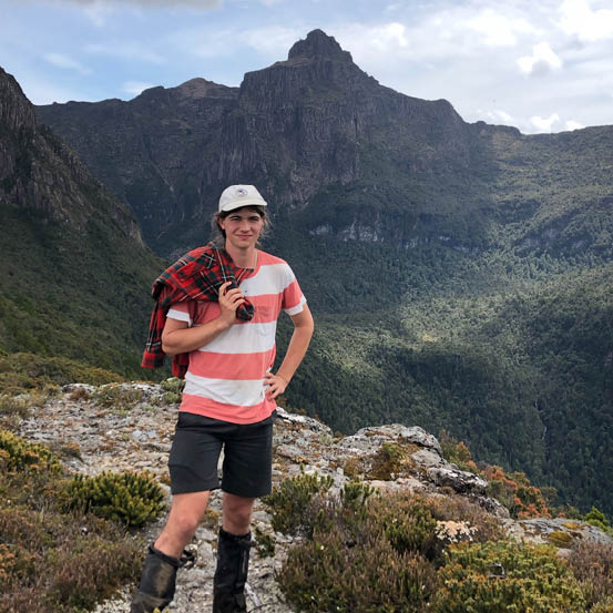
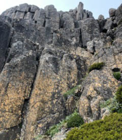
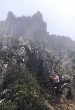
Bede on the ridge between Mount Lot and Lots Wife. Mount Anne in the background
Walking in Tasmania is always a close-cut thing. When you are forced to compete with a tempestuous, temperamental environment, the chance to walk even three days without rain results from a hefty dose of divine intervention.
Tasmanian walking always heats up around Christmas. It's really the only opportunity to walk that coincides with good weather. Being aware of this, I recruited early. I brought up the idea of a walk in Tasmania with my uncle Rob in October and we settled on the Mount Anne circuit.

4 | Bushwalk December 2022
It's always a good idea to have a casual glance at the mountain forecast before you embark on a trip. To my alarm, a southerly, the most dreaded of mountain winds, was forecast for the week we had planned for the trip. This is a recurring theme for me, as with most walkers in this region, I think.
What was lucky was that Monday through to Wednesday seemed okay, with no rain forecast.
Day 1: Condominium Creek, Mount Anne, Shelf Camp, 8.7 km, 8 hours We set out early on Monday, 4:30 am. It was a dismal sight. It rained until Hobart and as we came into Maydena, it poured. Turning down Scotts Peak Road, it rained. What luck! Like a biblical scene, the clouds were parting as we trundled up the road, and the sky became mottled with blue and white.
My grandfather had driven us to the start of the walk, and having donned packs, we began along the new boardwalk. The sight was intimidating. A long flight of stairs greeted us, steep and endless. We said goodbye, gulped and began the strenuous clamber up the hill.
It had been a while since I had stepped out on the track, and my walking fitness was not quite up to par. There was a lot of stopping and resting as we made our way up the initial steep slope, hindered further by the constant need to lift one's legs further than usual. However, my fitness slowly started to return to me as we continued, and I felt we were getting into a rhythm, an important point often
Mount Anne from the side of Eve Peak
"
The sight was intimidating. A long flight of stairs greeted us, steep and endless.


Uncle Rob and Bede on track
5


Bushwalk.com notes and maps on webpage, GPX and PDF
This map is © Bushwalk.com and is created using data © OpenStreetMap contributors
Mount Anne Circuit
Road, four-wheel drive track, walking track (treed)
Main track, side trip, alternate route
Cliff, major contour line, minor contour line (50 metre interval)
Lake, river, waterfall or creek


0 km 0.5 1 2 3 km

Start of the walk
Hut
Campsite
Toilet
Parking


6 | Bushwalk December 2022
overlooked by walkers. We took a brief stop at a little seat, and the view over Pedder had cleared brilliantly. It was cloudy above us, but the signs were good. What good luck!
We continued up onto the flat secondary ridge and could see the lower reaches of the scree slope below the summit taunting us. Then came another great ascent, and a small shower came over and quickly dissipated. The hillside was covered in low vegetation, such as pandani, and a large amount of charred debris. The damage from the 2018-19 fires was stark, and the vegetation, even now, was only starting to recover.
The slope was short but horrifying. Again, my lack of walking fitness was taking a toll. It seems here that the track shifts ridges, or else follows the side of the ridge rather than the top of it. I suppose this is to stop erosion on the top of the ridge, but I am not sure. It certainly makes the walking more arduous.
I believe that this section of the track has been re-routed somewhat. I never went up before this though, so I am not sure, but it took a little longer than Chapman said it would. This may well have been because we were not going very fast, but during the next sections, we had no trouble keeping to the times.
We were on the main ridge now and the cloud was closer overhead. We took a brief detour to see over the tip of the ridge down to Pedder and as before it was fabulous. The Western Arthurs were making a small appearance and, closer to home, Scotts Peak and Mount Solitary were showering us in their magnificence. The cloud was more broken now, and shafts of sun brought out a vibrant array of blues and greens, with the road a clear brown strip below us. Rob remarked that we could get a boat and take a trip out to the island peaks, an exciting prospect.
Upwards, ever upwards, but the going was easier now. It was quite a bit flatter, and the stairs were less rigorous. We could make out a glade of scrub in the distance, and I believed this to be where we would find the hut.
The track steepened again but not seriously. We darted around the side of a knoll before coming to a small, cleared area. I assumed this to be where High Camp Hut had been and that it had been destroyed, but after making our way up the track a way, we stumbled upon it, hidden in the thicket.
The hut was very nice. It was small and looked rather like a shepherd's cottage. It was made of un-shaped stone, and the gaps

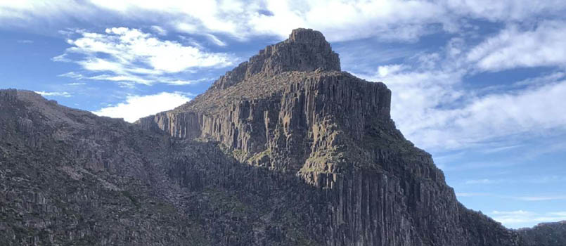
Mount Lot and Lots Wife from the summit of Mount Anne
7
were filled with mortar. I was sad to see that the fireplace had been filled in as I think that a hut without a fireplace is rather a paradoxical and even disingenuous sight. I was also fascinated that it had two levels with a very nice little staircase leading to the second level. I commend its makers, for it is a premier piece of hut building.
The next part of the track took us through a maze of fallen boulders, mostly vehicular in volume, the last sentinels before the summit of Mount Eliza. There was rather more technical climbing than one would predict, the crux being a five metre climb up a miniature gully, but nothing that would cause any alarm.
The views had reduced significantly as we had managed to tuck ourselves into the cloud band. What was encouraging was that the band had risen significantly. Again, good luck.
We met a couple of parties descending, their reasoning being that there was no chance of climbing Anne that day (ha ha). We chatted
briefly before going our separate ways. It is nice to see people having a good time in the bush, and one does wonder if our going up there in such weather had the potential for hubris. These people may have been far more sensible than me.
We finally summited Mount Eliza at about 10 am in thick cloud. For the moment, my gamble was firmly not paying off. Further down, we had decided on tea, and we set about getting the Trangia boiling and extracting some nibbles from deep within our packs.
The previous day we bought three blocks of chocolate whilst food shopping. One (the mint) was meant to be for the family back home, but later on when we wanted to eat it, we found it had disappeared. It had now, like a phantom, materialised in my pack. I was quickly accused by my companion of a minor theft, a charge I denied and still deny, although I was pleased to have it.

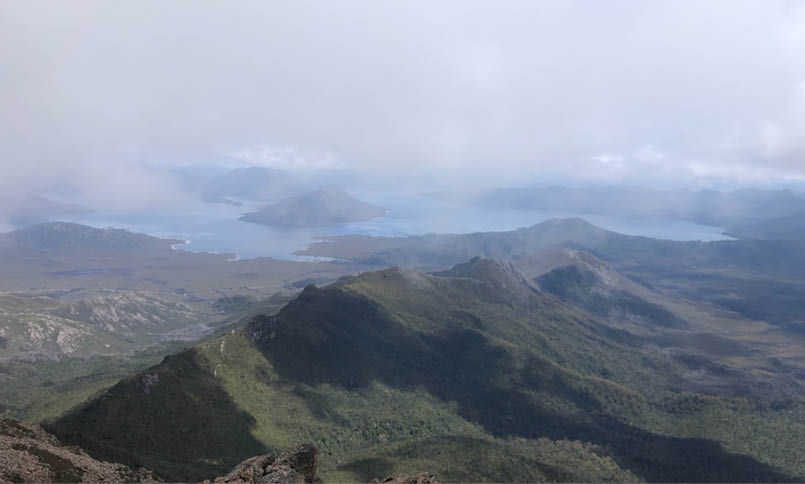
Lake Pedder from the summit of Mount Anne
8 | Bushwalk December 2022
I tucked into the stolen goods, and the tea quickly boiled. We were joined at the summit by three groups. One group was two fathers with their sons, who we had seen and heard from below. They quickly moved off, followed closely by a group of three men. They too moved off after a quick chat, and a couple came and sat some distance off. I believe they only came to the summit of Eliza, but they were there for the time that we were, and when we left, they were still there.
I was pleasantly excited to see the clouds above me glowing a hot yellow rather than their customary dull grey. The sun was
breaking through. It was an agitated wait as the breaks came and went, but it showed definite improvement. It was from these breaks that everyone present got a large amount of amusement. My exultance was expressed vocally with many ecstatic cries.
We duly packed up and made our way across the foggy Eliza plateau. It was a wet place with many little tarns which were perfectly flat despite the minor wind, most likely from the fact that they are often indented into the earth. It was covered in vibrant green mosses and cushion plants. The visibility was improving as we went, and we even got some glimmers
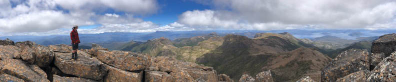
Panorama from the summit of Mount Anne

of where the plateau dropped away into Lake Judd in impressive walls with large boulders at their tops.
We came quickly upon the brow of Eliza Bluff, and the heavens parted. The sun came down upon us in shards, and I felt for the first time hot. The gamble had paid off - what a relief. Anne was not yet visible, being somewhat higher, but I was sure she would appear soon enough.
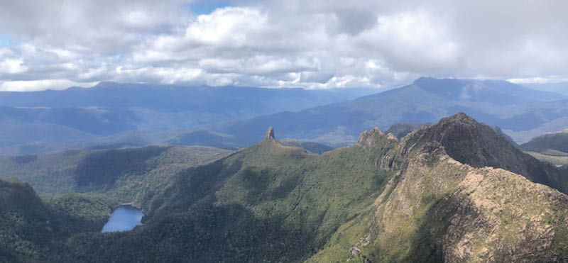
We crossed a number of little knolls in ever more sun, and as we came upon the peak of the final knoll, the great Mount Anne, the
tallest summit for miles around, broke free of her cloudy shackles. She was a magnificent beast, but very imposing. We could see the wall we must climb, some 10-15 metres in height.
Mount Anne rose in cliffs. Two rings to be precise. We made our way across down the boulder slope to the intersection of the circuit and the Mount Anne summit track. Here we dumped our packs, extracted a water bottle and began the journey to the summit. As we approached, a final plume of mist passed across Anne's flanks before she was rendered totally clear with a blue backdrop. The day had fined up magnificently for our attempt.
There is always a sense of foreboding with these things. That twinge of uncertainty is a niggle. We contoured around two knolls before coming onto the final scree slope. Cliffs barred the way. We made an angled ascent, aiming for the beginning of the final gully. As
"
The gamble had paid off - what a relief.

9
we reached its base, we saw a small crowd, including the group of three men we had met previously. We briefly chatted, during which they said they wanted to watch us first. Right.
One must put all emotions aside in this situation and work on the job at hand. I carefully climbed to the final ledge. My uncle came up beside me, and we made our way out onto the crux, 15 metre drop and all.
In front of us was a chimney with obvious good holds, and I found myself above it in no time at all. The depths below were a good excuse to get to better ground, and I made my way gingerly across the sloping ledge
towards safety. My uncle was with me as we got onto a blade and negotiated a large and confusing boulder. The route was then simple as we made our way along a ramp and then a short climb to reach the summit.
The summit region had a large number of boulders with large drops between them. The views were stupendous, extending to the very limits of vision. I could make out the furthest reaches of the Arthurs, the Franklands, the Pedder impoundment, and down to the Crest Range and Hartz and Adamsons Peak. The weather had cleared wonderfully, and everything was covered in light, creating vibrancy and dimension few get the opportunity to see in the southwest.
We stayed at the summit for a time, but the thought of the descent ate away at me until we decided to go.
The route was the same as it had been and no more daunting. When we reached the crux, it was over in no time. I gave a happy smile as I greeted a person going up, glad to have done the largest obstacle with no trouble.
We got back to the packs okay but noticed some of the other people were not moving past the crux, which was still plainly visible. As we set about making lunch at the track junction, we were shocked to hear the thunder of rotors and saw a helicopter making a beeline for us. We were even more shocked to see it make a few circuits of the peak and then drop a number of personnel around the crux, flying low and close to the cliffs, before gaining altitude to allow a second helicopter to do the same. We ate lunch and watched the rescue for two hours.
It was about 4 pm when we began the descent the Shelf Camp. We decided to camp down at the bottom of the shelf near a large
"
... we were shocked to hear the thunder of rotors and saw a helicopter making a beeline for us.

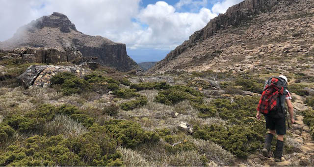
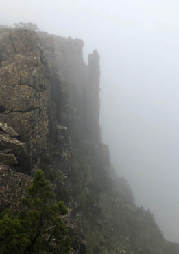
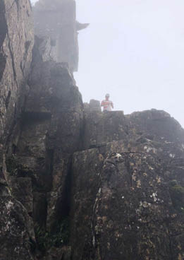
The beginning of the final summit scramble
"
One must put all emotions aside in this situation and work on the job at hand.
10 | Bushwalk December 2022
tarn. We discussed the rescue with a couple of fellow walkers there and found an empty tent, but little information more was gathered.
We had a good dinner of steak and a little pudding and then fell asleep.
Day 2: Shelf Camp, Judds Charm, Lots Wife, 7.7 km, 8 hoursThe morning came misty and chilly. Visibility was around 10 metres, and we made sure to stay away from the edge. I remark in my journal that it was so misty that the dew got caught in my hair and, rather more amusingly, Rob's beard.
We cooked a hearty meal of bacon, eggs and porridge, washed down with liberal quantities of tea, a must. Camp was struck about 7 am, and we began to make our way along the rather muddier track that sidles below the cliffs of Eve Peak.
The pad joined again with the ridge and what followed was an awkward crossing of large boulders that were scattered in large quantities along the top of the ridge. The fog was moving fast around us. It kept us well hydrated and made for an entertaining performance as we walked.
We came to the point where the pad leaves the main saddle and sidles along the northern face of the range. This exercise continued for some time before a large drop was climbed, followed by a tricky descent into the infamous Notch.
We were dwarfed by a large wall of rock with a cleft which offered an easy ascent. I was voted to go first. I tied the hauling rope in heroic style around my shoulder and set out. Again, everything was relatively simple, although it was more technical than the Anne climb. I came out onto the crux, with the full seven metre drop below me, found an easy way up and executed it without an issue.
The pack hauling was a chore with 20 kilograms of gear dangling from the rope, but we made it up. That was perhaps the most daunting part of the exercise, as manoeuvring around the drop with a 20 kilogram pack was more than a little exciting. But we came to no harm and were all safely up.
"
... manoeuvring around the drop with a 20 kilogram pack was more than a little exciting.
Mount Anne from Shelf Camp
11
We began to sidle around the southern face of Mount Lot. It was a decidedly rocky affair, culminating in a long slog up a scree-choked chasm. But we had reached the top and were greeted with clag. I made tea using a neat little ledge for the Trangia, all rather homely way up there in the clouds. The tea was delicious and I tucked into some chocolate (Rob isn't a fan). I had to eat a bar a day and I was decidedly behind.
The clouds did not lift, and so we were left with a rather dismal view of nothing at all. It was also decidedly chilly, but the tea helped with that. We made our way down Lightning Ridge to the south. The top of the ridge was hard to move along due to the scree and regular scrambling obstacles. There were a couple of particular cruxes, the most memorable of which had a two metre drop; not really worrying but one would not want to fall, as I nearly did, the rock being decidedly slippery.
As we made our way down, the visibility slowly increased so that as we came to the secondary ridge we were required to take, we found that we could see it from a good 20-30 metres away, a stark improvement. A thick rainforest was next, with a little lookout at the top. We clambered out of the forest and stood
overlooking an imposing drop. We were luckily secure behind a blade of rock, but looking down I could see a thick ocean of trees, and we even spied Judds Charm peeking through the mist. Most exciting.
We began the descent. It was a typical southwest scene. False leads and spindly plant limbs caught us as if it were all a children's game. I believe this forest to be full of children, for one slips regularly as if it were a pre-laid plan. Through gaps in the trees, we spied Lake Picone, but the scene was sombre owing to the excessive grey that pervaded all around us.
We came out at the Charm and stood a moment gazing at its unsliced surface. We took a look at the map and noted that around us the cloud had risen enough to see the walls of the main ridge in the north running north-south. It was an impressive sight, as if we were in a large giant's mouth.
We made our way over the final knoll and descended into the campsite at the eastern tip of Judds Charm. Here we met an educational ranger whose job was to tramp her way around the countryside explaining many facts, usually about the preservation of wild places. We had not registered our walk


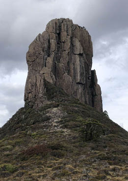
A dolerite column on the ridge between Eve Peak and Mount Lot
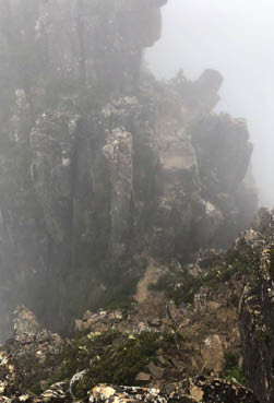
The descent into The Notch
The top of The Notch from the beginning of the descent into it
12 | Bushwalk December 2022
on the new registration system, not because I am against it, but because everything had been rather hurriedly organised. We hoped that we could avoid this awkward discussion by cutting short our conversation with some clever excuse. It was not to be. She eventually asked the question, and not wanting to cause a scene (although who was there to see it?) we fessed up. Her face changed very quickly. Gone was the jovial smile, and a serious tone came across it. It was perhaps the starkest moment of my life. She explained in no uncertain terms the issues with our course of action, and we nodded agreeably. Eventually, however, she relented, and we made our way to a nice tent platform by the Charm (the best in the place) and set up the tent.
As we were preparing lunch, we noticed with some dread that said ranger was approaching again, a cup of tea in hand. She mounted the platform, and we began a rather cheerful conversation about various things, including the climb up Lots Wife. Lots Wife had been a goal of mine. But only if the weather was good.
The weather was changing rapidly from its morning state of dreariness. The cloud was lifting, and Lots Wife was intermittently in view. The cloud was moving fast above us, and it receded in great shafts that clung to the mountains like octopus tentacles.
We munched on a leisurely lunch of salami, cheese and cucumber as well as large quantities of chocolate and bread. The weather cleared before our eyes and the Charm remained a carpet of glass. The sun was peeking through, as was the blue sky.
We decided to make an attempt on Lots Wife. We grabbed some suitable warm gear and made for the track to Lake Picone. We crossed over the rib between Judds Charm and Picone and descended to the outlet, forded it, and made our way through thick mud. The mud was to be expected. This is not
a maintained track but rather kept in existence by use. It is also somewhat of a marsh. We climbed the further rib and made our way into the dense jungle.
We were most likely one of the first along this route in some time, and this was obvious. It had become somewhat indistinct, with many false leads. It was not at all helped by a landslide which had removed the original track, forcing us to push through the scrub to effectively make a new one. We quickly came upon the top of the ridge, but we were barred by chest-high scrub.
It was here that I took a wrong turn and led us too far to the left of the ridge top, placing us in very thick scrub. Rob quite rightly took the lead, and we were quickly reunited with the route. We had a good laugh and then made our way onto the moor that stretches to the base of Lots Wife. It was a stupendous outlook. The sun was well and truly out, and Mount Anne glowed orange.
At the base of the cliffs we made our way along the north face. We followed an undulating track that crossed many small ridges, overshot, and came back to the correct gully. Ahead of us was a seven metre climb. It was the most technical of the lot, requiring a start in one small gully before crossing over to the other side and coming out underneath a large trunk. This trunk was a very good hold and I utilised it extensively. The track then pushed up through the gully before unexpectedly coming out of it and onto a face with grandstand views of the lakes surrounding the mountain as well as Mount Anne itself.
I was a little surprised and asked Rob to go out ahead; he has more experience in these matters. He confirmed this was the route and that it was quite okay, and we continued up and over a small climb before reaching the summit.
"
It was perhaps the starkest moment of my life.
"
Ahead of us was a seven metre climb.
13
We sat down on the summit, enamoured at our achievement. We leaned up against a rock and enjoyed the wonderful views out over the area. The Arthurs were peeking through, Federation rearing its head, beckoning me. There were the Franklands and Hartz Peak, and Mount Anne glimmered amazingly. Even Mount Lot was impressive, with its winged face, but we got rather annoyed that it had not given us the same views. We also saw Angel Falls in all their glory, brimming with water. It was an exciting thing to see the plateau fall away so spectacularly.
I must say that Lots Wife was by far the most rewarding climb. It was more technical than anything else, and it was also a real unknown whether we would get there. It required a better forecast than Mount Anne was as we would need two days of reasonable weather.
We descended without trouble and made our way back along the base of the cliffs to the plateau. We found we had a little phone reception and called home to tell them of our good fortune. There was a twinge of sadness for me though. The hardest and most exciting part of the walk was over. That is always a sad part of a walk like this. I think that is the saddest part about bushwalking, that it must end.
As we descended, we came across a large crack in the earth, about a body's width and a good five metres deep, easy to fall into it. We had not seen it on the way up. It was such a fascinating occurrence that when we got below the ridge top we tracked back to find its source. It turned out to be about 50 metres away but was nowhere as large meaning that if one fell into it, it would be very difficult to escape. We then made our way down the woody ridge to the plateau, finding it no easier than when we came up. I even managed to fall over with some pain onto a tree trunk.
We reached the floor quickly and tracked back over the first of the ribs, then through the Picone basin, over the second rib, and down into Judds Charm. Here we met the ranger again and informed her of our success. She joined us for dinner. I believe she must have been somewhat lonely traipsing about the bush on her own. I couldn't blame her really. The bush is a big place and when you have no one with you it gets tiring after a while.
I managed to stuff myself with a bar of chocolate in this period, a necessity given the issue of too much chocolate we were cruelly faced with. Punishment for our good weather, I think.
Bede descending into The Notch
Bede unfurling the hauling rope and the top of The Notch
Lots Wife from the approach ridge
14 | Bushwalk December 2022
Bede lives in Brisbane, Queensland. He grew up in Tasmania where he got his passion for bushwalking. He is kitchen hand at a restaurant whilst he finishes school. Bede likes bushwalking because it is an exciting exploit, allowing one to have many great adventures, and it also allows him to see the most beautiful and remote parts of our country. It also gives him something to have a good chat about after the walk is over.

"

Day 3: Judds Charm to Red Tape Creel, 11.9 km, 6 hoursThe next day dawned better than the previous. A kind goodbye from the circuit. We struck camp at 7 am again because we needed to be out by about 1 pm. We coursed across the Charm's basin splendidly. The low scrub and the flat surface allowed us to take long strides.
We remounted the ridge by a direct and tiring route and made our way along towards Mount Sarah Jane. This mountain was striking, but I believed the climb is fairly easy from Judds Charm. However, we decided to give the quad a miss and make our way down. The wind was also blowing swiftly over the ridge top, and it was all rather chilly.
We crossed the moorland around Judds Charm with some difficulty. The textured plain made the going tough and was in a couple of places combined with walls of scrub. The mist came over up there but by the time we came to the descent of the range it had passed. The view down to Lake Judd was very pleasing, but rather teasing. It seemed so close, but a tough scrubby decent barred the way.
We stopped at the gap and surveyed the clearing view. It was nice to look down the Anne River Valley, watching its windings and viewing the sheer faces it had carved. Some we had topped; others would have to wait. It was here I made the biggest navigational error. We descended down a faint pad. It was
the wrong pad. What followed was an ever more difficult bash through the scrub. We were continually pulling out the map but to no avail. We decided to aim southwest and try our luck and by some miracle we managed to descend to the lake.
This took a chunk out of our time so after a quick look at the bridge over the Anne River we started to push on.
The final walk out was merely a slog along the floor of the Anne River Valley. It was largely a flat track and very beautiful country. A welcome change from the up and down scrambling of the range.
After about an hour and a half we came to the Anne River suspension bridge where we stopped for lunch. It was a cheerful thing. Looking down the river we could see where it heads into a large gorge. It was almost Austrian in appearance and very impressive.
We then donned our packs for the final slog and climbed over the small ridge on the right bank of the Anne River and down into the Lake Pedder catchment. After 30 minute walk down the hill, we reached the logbook shelter and the end of the walk.
I had a great time! It is highly recommended! I would also say that this trip was full of bloody good luck. The weather held out wonderfully well, and although we got lost a couple of times, we got back promptly. No one got hurt, which is good.
15