
How far is it?
Text Matt McClelland


We have all been there. The sign, map and the website say it's a 10 kilometre walk, but your device at the end of the walk says it was 12.78 kilometres - what gives? It's not just about GPS accuracy. Surprisingly, it's impossible to give the definitive correct length of a walk.

52 | Bushwalk February 2023
It's obvious that the grades and the times for walks are at least partly subjective, but much more surprisingly it's not possible to give a perfectly accurate length for a walk. I know that seems ridiculous, but a good answer is possible. This article takes a stroll through some nerdy complexities of geographic concepts that highlight many of the reasons why the distances for walks vary between authors.
Now let me be upfront. These variations are minor and will not usually give lengths that vary widely; they will generally be in the ballpark. By the end of this article you will see why it's impossible to have the “correct” length. On the way you will also see why walks are also infinitely long, for the truly pedantic theoretical types. In the real world most authors cite distances well, but some are just plain wrong in my view, and sometimes it matters.
Resolution versus accuracyIt's not unusual for me to get an email from a fellow bushwalker asking why my book says a walk is only 15.2 kilometres when it's “actually 20.12545 kilometres.” Some devices give distance travelled to lots of decimal places, resolution of centimetres. Such a confident result makes many people assume it's very accurate, however a high-resolution answer is not necessarily an accurate one.
A big challenge when doing any measurement is knowing the accuracy of the system you are using. Ideally you would always use very high resolution with very high accuracy, but that would lead to challenges like cost, data collection limitations and data management issues.
Small inaccuracies add up And they add up very quickly. In good conditions your GPS might be accurate to about 5 metres, but the error is not consistent. So if you were to draw the GPS on map with the line you actually walked, you will see the GPS line zigzagging back and forth over your actual path. These little zigzags can add up to a lot. Just imagine how much further you would walk if you zigzagged all the way along the the track, let alone how drunk people will assume you are.
It's common for a GPS to keeping adding distance walked as you sit over lunch. While sitting on a rock, the GPS is not moving but the imperfect readings make it look to the GPS as if it constantly moving a few metres around your actual rest spot, like a lost zombie. These small zombie movements add up over your rest break adding significant length to the recording. If your GPS is pointing away from the sky when you rest then these zombie movements will get even bigger. Some GPSs might use some other sensors to reduce this kind of error, but it will still happen.
Imagine your measuring device is a pedometer that just counts your steps. Even if it counts the number of steps exactly, every stride is a different length. Generally this might average out okay, but whatever we assume is the stride length will not be accurate. Your stride also varies with the terrain.
Big errors happen a lot GPSs work best with a clear view of the sky, the clearer the better. The more the view gets blocked by trees, cliffs and thick clouds the more errors occur and the bigger they are. That zigzagging can get crazy, so crazy it will be obvious it's wrong as it might bounce around by hundreds of metres between each
"
... the system just takes a good guess, usually reducing the error, but it's never going to be perfect.


Small measurement errors can quickly increase the calculated length
53
measure. There are systems to clean this up, but the system just takes a good guess, usually reducing the error, but it's never going to be perfect.
Some tools like a GPS allow you to attach better antenna to reduce the errors, but all measuring tools will make errors. With care we can reduce these errors to a point where they will not be noticeable to walkers.
Resolution matters Resolution is not only the number of decimal places in the length but also refers to how often we collect data. With a GPS the more often you collect and store a location point increases the resolution. Most commercial GPSs can do this every second. Prosumer ones might do it 10 times a second. A bushwalker does not usually move terribly far in a second so we do not need extremely fast GPSs.
Imagine walking a track with a lot of switchbacks. If the GPS does not capture a position at each bend, then the GPS line will look like you have cut the corners. In an extreme case it might even look as if you walked straight up the hill, measuring a much shorter travel distance. As you reduce the number of measurements you take, you will reduce the calculated length. After all, the shortest distance between the start and end is a straight line, just two points.
There is a paradox here. As you increase the number of GPS points (the resolution), then you increase the number of errors recorded adding to the calculated length. If you reduce the number of points, you do not measure all the bends in the track, leading to a shorter calculated length. There is no “correct” sample rate; just know that changing the resolution will impact the calculated length of the walk.
All measuring systems have inherent errors and as we take more measurements (increase the resolution) we include more errors. Imagine using a tape measure. The more often you measure the more errors are created, but the longer the tape is used the less detail of the bends in the track is captured.
A trundle wheel has a circumference of one metre that counts each rotation as you push it along with a handle – often considered the gold standard in measuring routes. You could see that a very small trundle wheel with a 10 centimetre circumference will capture a more detailed measure of the track, but each little slip error will adds up quicker. If you were really silly about it you might create a trundle wheel with a circumference of 100 metres; then you have a very low resolution measuring system – and some serious practical issues.
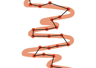
A GPS measurement (black line) at lower resolution misses important parts of the path (orange line)


Impression of what an absurdly large trundle wheel and a brave bushwalker might look like
54 | Bushwalk February 2023
Maths helpsSometimes errors are fairly predictable, so there are tools you can user to help reduce the errors. GPSs can even calculate the margin of error for each point. There are many fancy algorithms that help smooth things out and improve accuracy. These are helpful, but since I am being pedantic here, all they really do is throw away data and smooth things to be more “normal”. You can imagine how these could get carried away on switchbacks and smooth them out. In reality, if you are doing this kind of field data collection at scale you will use some tools to remove errors and then visually inspects the edited GPS line on a digital map with aerial and ground images for verification and small manual edits. Other tools can help improve GPS accuracy by correcting errors that occur due to changes in
the upper atmosphere. These errors pale into insignificance compared to walking near a cliff wall, cliffs and other large objects can really mess with GPS signals.
What do we actually measure?Even if we could measure perfectly then the next big issue is what do we measure. Well the track - isn’t that obvious? There are different ways of measuring the same thing, all with different results, but all can be considered correct.
Picking a lineImagine you have a circular track. If one person measures the inside and another measured the outside then then outside will be longer. Neither is a wrong choice. The common standard is to measure the centre
55
line in this case. Even if everyone measures everything perfectly but use different approaches, then we get different results. The difference would be small and there is a common standard - so let's look at some other differences that will have a bigger impact.
Length or displacement? This one surprised me. Someone emailed me asking if the “distance” I provided was the length of the walk or the displacement, the straight line distance from the start to the end. I had never considered that some people might think that, but it's ambiguous and not stated. So even if the “correct” measurement is provided it's important to be sure that walkers know what it actually represents.
It's possible that an author could document walks using displacement. It would be weird that all circuit and return walks are zero kilometres, so I doubt they would see it as helpful for very long.
After getting this email I stopped using the term “distance” and started using “length”. I also saw that the term “distance” could mean the how far it is from where you are to the start of the walk, especially if using a digital device. Standard language matters.
Length of the walk or the track? This decision can say that a track is 10 kilometres when the return walk is 20 kilometres. There are two main standards for track grading and communication in Australia (yeah, dumb I know). The Australian Standard 2156.1-2001 says in part it exists to “provide
consistency of information to users of walking tracks” . When talking about signs it says “Distance to a designated point.”. This was understood by many to mean that a return walk to a lookout should have the distance to the lookout (not the length of the walk back to the start). The first few drafts of Australian Walking Track Grading System stuck with this idea, but later made it clear that you use the out and back (total walk) length. I am still surprised that people ask me if the length of the walk includes the return leg. This kind of ambiguity is what leads to some of the variability we see in walk lengths.
What to include? So if you are documenting a walk that has optional side trips that are very popular, should you include them in the total length of the walk? Some people do, some don’t. Some say the walk is 10 kilometres (+200 metres), which is cool for power users but can create more confusion in others.
How about a harbour walk that includes a ferry trip or an alpine walk with a chairlift partway through a walk? You need to travel using them to complete the walk, but you are not actually walking. Personally I do not include the ride distance in the total length but some people do. For a walk with person powered boat trip or swim? Well, maybe I should include it because there is effort, but it's not walking - so I don’t know. There are so many nuances. This is before we get to walks with alternative routes and other options along the way.
Tracks change Walking tracks change a surprising amount and these effect the length of the walk, usually a fairly small amount. Tracks get realigned often to avoid sensitive areas, reduce erosion, to improve safety or access to views. Sometimes these are planned and built by

Length of trackDisplacement distance
"
Personally I do not include the ride distance in the total length but some people do.


56 | Bushwalk February 2023
land managers; sometimes they just happen as people start walking a slightly different route. Then of course some walks are off track, so what is the exact length of that?
Remembering we are being pedantic here, so hear me out. Walks in snow or through sand dunes change in length over time if the up and down movement of the walker is carefully measured; the snow forces them to walk above the path and as the sand dune erodes it reduces the length. These might even change depending on how many people walk before you. Yes, most changes are tiny and will not matter practically, but I reckon it's an interesting issue when we live in a world where people expect accuracy, but do not have the time to dive into the complexities of what seems simple.
Including the hills? Some length measurements for walks include the hills and some assume it's flat. Let’s simplify things for a moment and draw a hill as a simple triangle. We know that the base of a triangle is always shorter than the length of its two sides. In this simple example the height of the triangle is the hill, the base of the triangle is the horizontal distance travelled (the line on the map) and the side of the triangle will show the physical length of the actual track. The steeper the hill, the longer the sides get – this means the track we walk is longer than what is shown on the map.
So, should the length of the walk be the horizontal length shown on a map or how long a piece of string would be if placed along the path? I don’t know. We could have very reasonable conversations that both options have their benefits and drawbacks.
Some publishers will include the vertical gain and loss along the walk in the walk statistics. If they were to include elevations changes in the length as well, then it might seem to exaggerate the difficulty of the walk. When including the vertical gain/loss statistic, some include it cumulative and some by the difference from the start and end. If doing it cumulative, then resolution matters a lot again.
There is also one very big hill that also has a tiny impact on the length of a walk - the curvature of the Earth. Take a pair of scissors and cut the edge of a circle and you can see the hill very clearly. Since the actual curvature varies across the earth and depends on the direction we are travelling in the maths can get complicated. The actual impact is tiny but it's still interesting to consider.
Hills are common and complicate the matter of measurement a lot.
All walks are infinitely longIf you are a real maths nerd, you know where this is going (sorry to call you out). In the mapping world there is a cool mathematical problem called the Coastline paradox.
The Coastline paradox is a phenomenon impacting how you measure the length of a coastline. The more detailed the measurements taken the longer the coastline appears to be. This is because coastlines are not smooth, but jagged - full of small bays and inlets. So, the more detail you measure,

Hill height
Length of the track on the groundLength of the track on a map


"
There is also one very big hill that also has a tiny impact on the length of a walk - the curvature of the Earth.


57
the more bays and inlets you will find, and the longer the coastline will appear to be. This is similar to the resolution issue we discussed earlier.
Now this is where things get a bit more theoretical, a conversation you would have with Sheldon Cooper perhaps. If you keep zooming in on a bay, you will see there are little bays within each bay. Zoom into a little bay - more little bays. Yep it keeps going forever, imagine all the little bays around each crystal within the rocks and grain of sand on the beach. Oh, and each of those crystals will have little bays in each atom (and it keeps going).
If you were to measure a coastline with infinite or near-infinite resolution, the length of the infinitely short kinks in the coastline add up to infinity. This is known as the divergence of the fractal curve.
The walking track paradoxYou could argue (with your very patient friends) that the Coastline paradox happens with many hiking tracks. Tracks do not appear fractal shaped like coastlines, so let’s think another way. Turn the track on its side to look at its topographic profile – now that looks much more like a coastline.
As you walk up a set of stairs you walk in a straight line. Now think about a small lizard beside you. With shorter legs our little friend
needs to walk much further following each riser. The ant walking beside the lizard not only follows the risers but needs to go up and down over each stick and pebble. The flea does all that and over each grain of sand. A baby fairyfly needs to negotiate over the crystal edges of each grain of sand and the grain in the wood of the steps. The smaller you get, the further you need to travel, all the way to infinity.
I am not proposing that all walking tracks are listed as infinite kilometres. However, it's helpful to go through thought experiments like this to get a sense of how complex seemingly simple things can be. The more you understand a topic the more simply you can explain it, but is also true, that simplistic answers become more difficult to ignore.
If you create a standard measuring the length of a bushwalk, just agreeing on what resolution you choose to measure both vertical and horizontal changes in would not be obvious. No publisher is going to be stupid enough to measure walks at the atomic level, but if we want consistency in walk lengths then we need to agree and standardise what is actually measured.
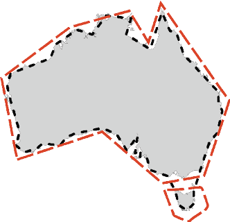
Two Coast line measurements of AustraliaLower resolution = shorter measurementHigher resolution = longer measurement

"
The smaller you get, the further you need to travel, all the way to infinity.


Creatures not to scale


58 | Bushwalk February 2023
I am not sure my kids will appreciate my response that it's infinite kilometres to the campsite. Meanwhile, we can just smile when we see a discrepancy, knowing in our hearts that we just completed a walk with a truly infinite length.
“For every problem there is a solution which is simple, clean and wrong.” — Henry Louis Mencken.
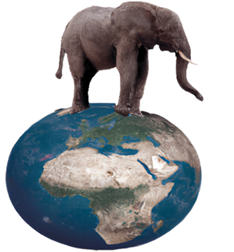
The Earth is not roundTo the shock of many on the internet, the earth is not flat, nor is it a perfectly round ball. Moving from the atomically small, let's look now at the big-picture view.
The Earth is a chubby sphere (close to an ellipsoid), where everything bulges at the equator as the earth spins. In fact, the shape changes constantly, the oceans are not flat, but change daily with tides. The crust even moves a bit each day and even entire continents are moving around a tiny bit each day. Chuck in earthquakes and meteor strikes, and we can stop thinking of the earth as a perfectly smooth bowling ball.
The earth feels hilly to us, but shrunk to the size of a billiard ball, it would be smoother than your average billiard ball. Our brains struggle with the scale of things we do not interact with.
One of the problems with mapsMost walks are measured with data collected in the field - with all the imperfections mentioned above. The walks are then laid over an imperfect map with an imperfect understanding of the shape of the earth.
To make a map, we take a three-dimensional earth and squish it on a two-dimensional map; parts of the map must be distorted to make everything line up. Imagine trying to peel an orange and lay it flat. When you go from a 3D ellipsoid to a flat map, you are going to either have to stretch/shrink areas, change the shape or direction of lines or leave gaps. It's never going to represent the earth perfectly. Because of this distortion, the more area a map shows (as we zoom out) then generally the less consistent the scale for distances are across the map.
We call these deliberate distortions map projections. A projection is created using a carefully defined series of points called the datum. A datum is really a mathematical model based on a specific ellipsoid (a defined shape of the earth). A datum defines the origin, orientation, and scale of a coordinate system. There are many different datums in use around the world, each with its own set of parameters and characteristics.
We are not getting into the details of map projections, data and ellipsoids; just remember they all have a slightly different view of the exact shape and size of the earth. This means they will give different results as they measure distances between two points or the length of a path. In the Geographic Information System (GIS) world each system has known strengths, weaknesses and best use cases.
For bushwalkers, it gets extra confusing because we use different systems. We often use the Mercator projection for online and app-based mapping systems, a different one for topo maps, another for managing GPS data and another for measuring stuff.
59
Map projectionsSome smart people created the idea of map projections, a way of representing the three-dimensional surface of the earth on a two-dimensional map. We now know that it's not possible to create a map that is completely free of distortion, but projections give us a way to understand the distortion. There are lots of these projections, let us just look at a couple.
Mercator projectionThe Mercator projection is most commonly used for world maps and nautical charts. It distorts the size of land masses near the poles, making them appear much larger than they are. This projection has the least distortion of any other map projection in the middle latitudes, but it exaggerates the size of the land masses near the poles. Think of most world maps you see and most online maps.
MGA94 projectionWe also use the MGA94, which is an implementation of the Transverse Mercator projection on most of your paper topographic maps (remember them) in Australia. It's based on the GRS80 ellipsoid and provides a high degree of accuracy across Australia. The MGA94 is also compatible with the World Geodetic System 1984, which is used by most GPSs.
In the real world, what does this mean? Let's look at the Overland Track from Ronny Creek to Cynthia Bay (no ferry) ignoring all side trips and going to each hut entrance. These are four different length calculations based on exactly the same line but projected using these different systems.
Projection system
Distance kilometres
Mercator projection
105.29
AMG zone 51
81.86
MGA94
83.99
GDA94
78.78
Using the Mercator projection gives longer lengths as it stretches space more the closer region is to the poles. The other systems give us more realistic values. These other three values are slightly different, none of which affects a walker in a significant way. So which system to use? Tasmap uses GDA94, but will that be the most accurate across the whole state? We know different systems will give different results in different areas, even before we put 3D datums into the mix. There are so many decisions publishers need to make when calculating the length of the walk. No publisher will be aware of all the details of all the moving parts. Computers are great, not perfect, and GIS is much better than running a piece of string or a wheel along a paper map as I did a few decades ago.
Human errorAlthough not really on theme with the rest of this article, this is still worth talking through. People make mistakes; the more stuff we do - the more mistakes we can make. I have seen many simple typos (including on government systems) that need to be corrected, like promoting a 4.1 kilometre walk as 41 kilometres.
Some publishers do not make measurements themselves but instead copy other people’s results and tweak them by a few hundred metres to hide the fact they are copying. Then someone might do the same with their modified result. One state national park website even made an “oops” when updating data records that left most of their circuit walks published as half their “actual” length, a 24 kilometre walk said to be 12 kilometres.
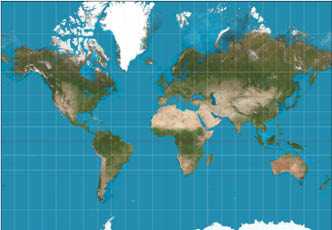
A Mercator projection of the world. The purpose of the image is to highlight how a 2D representation of the world is not accurate.Daniel R. Strebe, CC-BY-SA-3.0
60 | Bushwalk February 2023
We all make mistakes and part of the job of people who publish information like this is to keep improving systems to do more and more sanity checks on data to avoid obviously wrong information.
The most worrying mistakes we can make are due to issues we are not aware of. We do not know what we do not know. Many publishers have no idea how they actually calculate the length; the computer does it. So some people will use an inappropriate map projection that was tested heavily in Queensland, then use it in Tassie. Or perhaps assume that the fancy watch that gives the distance to five decimal places must be very accurate.
So what?In most cases, the variations are small and will not impact walkers. However, we need to be mindful that errors are not uncommon. We can do our own sanity checks and ensure we have the capacity to deal with some variations.
But for some people, if their watch tells them confidently that their walk was 20.12545 kilometres, they might lose trust in a publisher who said it was shorter. People new to bushwalking might find it overwhelming as they research a walk to find differing grades, times and lengths.
Consistency can help build confidence. Standards help not only to improve consistency but in developing systems as we
have robust conversations and tease out all the issues that actually matter. Then hopefully, settle on a set of standards that are easy to apply and help give bushwalkers more confidence in what they do.
I am not advocating that we develop such a standard now. In Australia, we have two walk grading systems that contradict each other and neither provide the information walkers really need. We have no standard for determining suggested walking times. I think there are other more pressing issues before we work out standards for lengths.
So at the end of the day, as experienced walkers it might be helpful to acknowledge that it's impossible to get the length of a walk “correct”, but at the same time, we can say that some lengths are just wrong. It might also help to let our walking buddies know that their pedometer, GPS or step count is not as perfect as they might think it is.
Until we can define what we are measuring when it comes to walking tracks, we can be happy with the idea that a walk's length is generally close enough but never exact. Most importantly, we should smile and know that those ants have to walk much, much further than we do.
"
I have seen many simple typos ... promoting a 4.1 kilometre walk as 41 kilometres.

"
In Australia, we have two walk grading systems that contradict each other and neither provide the information walkers really need.


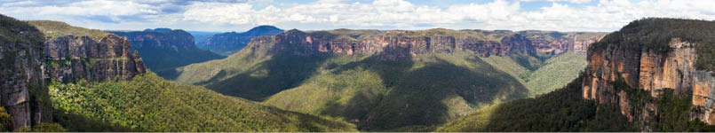
The Grose Valley in the Blue Mountains, NSW
61