The Western Arthur Range Traverse
Text and photosRebecca Jacobs
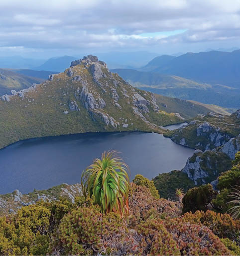
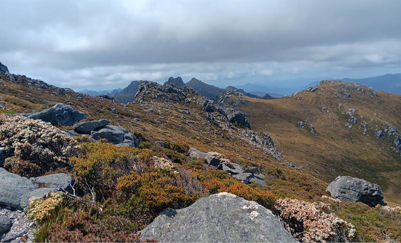
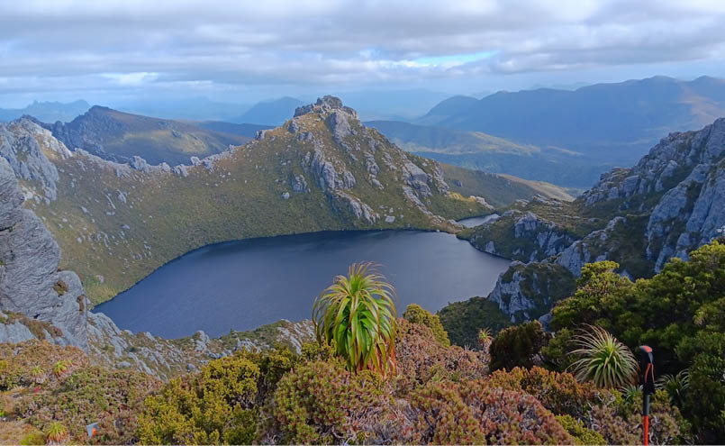
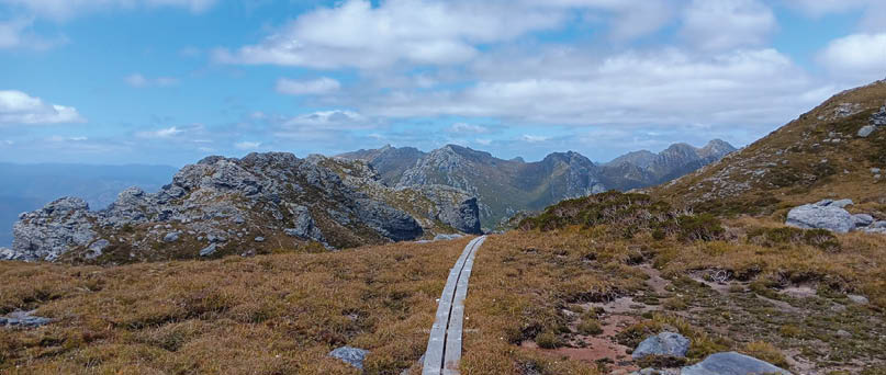
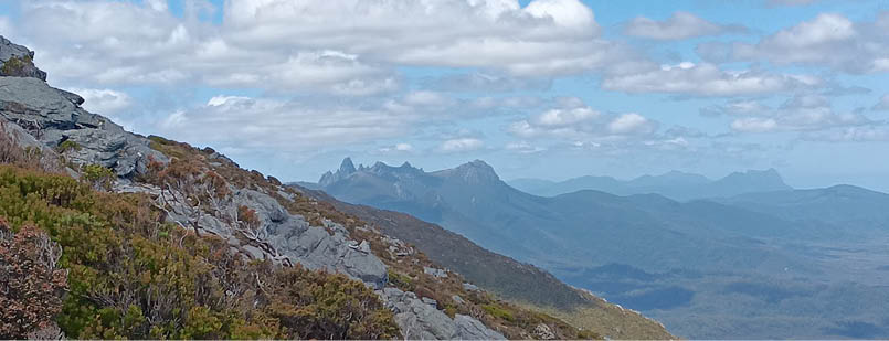
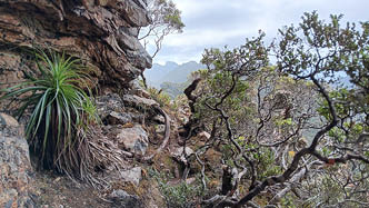
Day 3: Lake Oberon prior to final descent
After doing a lot of reading for the past couple of years, scouring over social media posts on local hiking pages and literally watching every video that I could find, the time had finally come for me to tackle the well-known Western Arthur Traverse, or colloquially referred to by locals as the Western Arthurs. I mean, who doesn’t want their own picture-perfect shot looking down into Lake Oberon?


22 | Bushwalk June 2024
"
The week before I had successfully summited Federation Peak on the Eastern Arthurs.


Federation Peak
The Western Arthur Traverse is a challenging and spectacular hiking route located in the remote wilderness of Southwest Tasmania, Australia. Spanning approximately 50kms through the rugged and pristine landscape of the Tasmanian Wilderness World Heritage Area, this traverse offers adventurers like myself a truly unforgettable journey through some of the most breathtaking scenery in Tasmania or, arguably, Australia.
I will have to admit that I went into the Western Arthurs with a quiet sense of confidence. The week before I had successfully summited Federation Peak on the Eastern Arthurs. Federation Peak is an iconic and challenging mountaineering destination. Rising to an elevation of 1,224 metres, its distinctive blade-like summit presents a formidable ascent, requiring technical climbing skills and nerve. Surrounded by rugged and at times somewhat delicate terrain and unpredictable weather, reaching the summit demands careful
planning, stamina, and a deep respect for the wilderness. It’s no secret that Federation Peak has been referred to by many as “Australia’s only real Mountain”, and after completing it, I can confirm that this is for good reason. So, I gathered when the two are compared, the Western Arthurs should be easy, right? ... Wrong! As I set off on day one, little did I know how wrong that quiet sense of confidence could be.
The traverse begins at the car park at Scotts Peak Dam, where hikers embark on a multi-day journey that takes them deep into the heart of the Arthur Range. The route traverses a series of deep valleys, jagged peaks,
23

dramatic cliffs and alpine lakes, offering stunning panoramic views of the surrounding wilderness at every turn. The terrain is rugged and demanding, with rocky ridgelines, steep ascents and descents and challenging scrambles that require careful and sometimes precise navigation and physical endurance.
Due to its remote location and challenging terrain, the Western Arthurs is best suited for experienced hikers with strong navigation and wilderness survival skills. Hikers should be well-prepared with appropriate gear, including a suitable 4-season tent, an adequate sleeping system, warm clothing, sturdy hiking boots, ample food, water supplies, personal locator beacon, first aid, and tools for navigation. It is also essential to be aware of the unpredictable weather conditions and to plan for contingencies in case of emergencies.
To make the hike sound a little less overwhelming, I have decided to break the walk down into a day-by-day recount of what sections we covered each day and the highs and lows our journey entailed. It is important to note that others may choose to break up
the walk differently and many choose to do it over additional days. In hindsight, this choice is probably a wise one. Our original plan was to complete the traverse in 6-7 days. But with the weather forecast looking less favourable on days 6 and 7, we decided to cover a little further each day and completed the traverse in 5 days. If you know much about Tasmanian weather, one thing you will know is that the weather is incredibly unpredictable and often unfavourable in the southwest. For our 5 days we got lucky. Extremely lucky. Albeit, we were still prepared for if the weather turned.
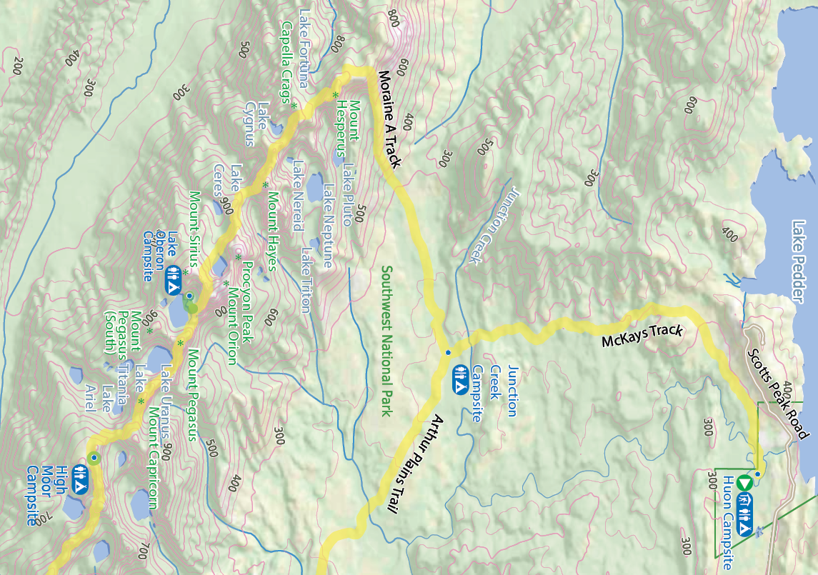
Day 1: Scotts Peak Dam carpark to Junction Creek Campsite ~ 9km, 2.75 hrs
Day one was our shortest day. Our group of four was unable to meet at the track start until the afternoon. With this in mind we decided to at least make a start and walk in to Junction Creek where we would set up camp for our first night on the track. The McKays Track from the car park to Junction Creek camp is moderately flat, open, clear, well-marked and easy to follow. We were quite lucky to

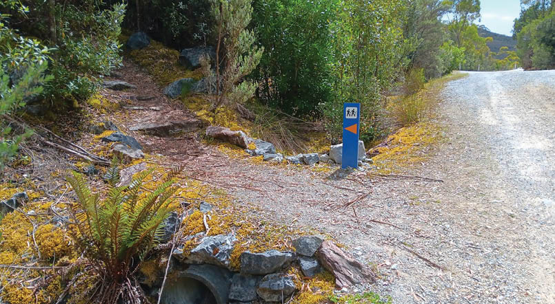
Start of the track
24 | Bushwalk June 2024

Start of the walk
Campsite
Toilet


Road, four-wheel drive track, walking track (treed)
Main track, side trip, alternative route
Cliff, major contour line, minor contour line (50 metre interval)
Lake, river, waterfall or creek


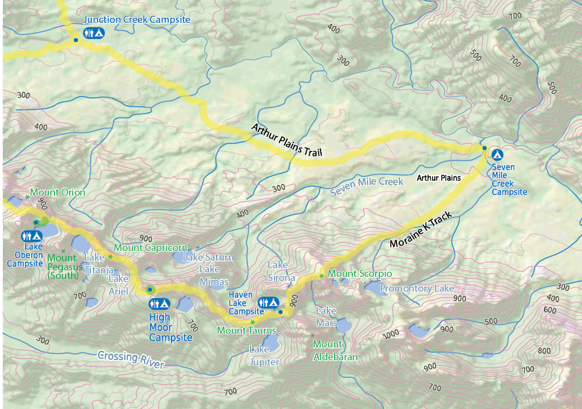
The Western Arthur Range Traverse, part 1

0 1 2 3 4 5km


Bushwalk.com notes and maps on webpage, GPX and PDFThis map is © Bushwalk.com and is created using data © OpenStreetMap contributors
25
only encounter a small amount of mud that wasn’t too deep. It was however obvious that sections of this track would be incredibly muddy in the wetter months and hikers would likely encounter the additional challenge of wading through deep mud.
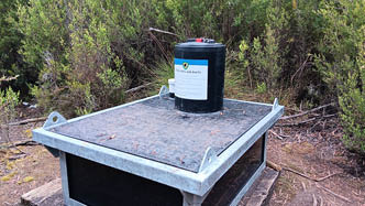
The Junction Creek Campsite itself offers a range of areas for one to pitch their tent both nearby the creek amongst the trees or a little further away on higher ground with a stunning view of the Arthur Range in the background. We completed the Traverse in January this year (2024) and the creek was actively flowing, providing a good source of water. Near to the campsite is also a barrel screw lid toilet for use, but you will need to carry in your own toilet paper.
"
We completed the Traverse in January this year (2024) and the creek was actively flowing, providing a good source of water.
Toilet at Junction Creek Camp

Junction Creek Camp
Arthur Range from Junction Creek

26 | Bushwalk June 2024
From the summit of Mount Hayes
Day 2: Junction Creek Campsite to Lake Oberon with side trips
~ 13.5km, 11.75 hrs, including side trips:Mt Hayes - 600m return and 25 mins, Mt Sirius- 800m return and 30 mins and Mt Orion- 800m return and 40 mins.
Today the plan was to walk from Junction Creek Camp to Square Lake, skipping Lake Cygnus with a side trip to Mount Hayes, one of the 5 Abels on our list to tick off. We woke up to an overcast morning and the ground was wet after a light shower of rain overnight. We set off early at 0730hrs following the ‘Old Port Davey Track’ and then onto the ‘Moraine A Track’, knowing we had a big day ahead, and quickly found ourselves ascending our first climb up to the open ridgeline of the Arthur Range. The climb was steep, but easy to follow. A slow and steady approach found us up the top and commencing the traverse in good timing. The overcast morning had begun to pass but the wind had picked up, although still pleasurable walking weather.
Beginning of the traverse
Heading toward Square Lake
27
Mount Hayes was our first side trip. The summit sits at an elevation of 1,119 meters. From the track, it took just under half an hour to reach the summit. The track start for Mt Hayes was not obvious. We relied on a GPX file saved on our Garmins to find the start, although quickly picked up a pad to follow which had some cairns sparingly as well. Before we knew it, we were back down and continuing on to Square Lake where the plan was to pitch our tents for the night. We reached Square Lake at 1600hrs. Square Lake was stunning, but we soon realised the ground was quite wet and the sensitive terrain lacked ideal camping spots for 4 tents. We quickly re-assessed and decided we had enough daylight hours left to head on to Lake Oberon via the summits of Mount Sirius and Mount Orion.
Mount Sirius was our next side trip after a short and steep climb out of Square Lake to the plateau. At the plateau, the track to Mount Sirius was to the right off the main track.
Lake Oberon prior to final descent
Heading toward Mt Sirius Summit
From the summit of Mt Orion
28 | Bushwalk June 2024
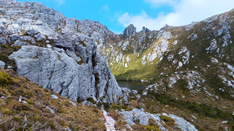
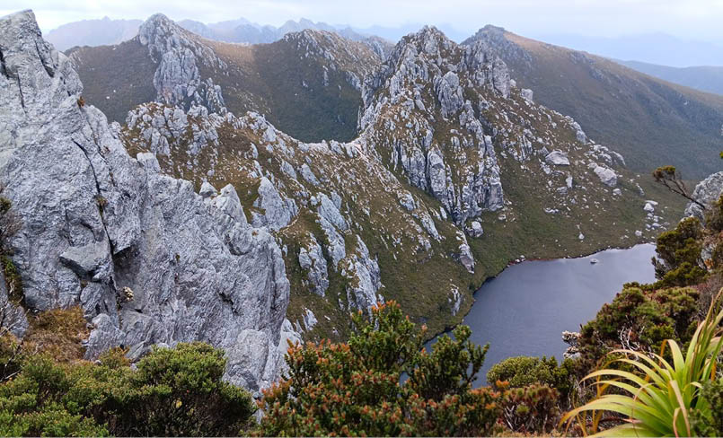
Again, the start of this track was not obvious, but we picked up some cairns to follow after relying on our Garmins to point us in the right direction. The summit of Mount Sirius sits at 1,151 metres elevation. In terms of difficulty, the climb itself was easy and showcased incredible views of the range as well as down to Lake Oberon.
After returning to the main track still in good spirits we decided to venture on and tackle Mount Orion. The last of our Abels on the list to complete before Lake Oberon. The summit of Mount Orion also sits at 1,151 metres elevation, but in terms of difficulty, it was harder than Mt Sirius and Mt Hayes. Truth be told, this may or may not be compounded by the fact that we had already been hiking for close to 10 hours and were noticeably starting to fatigue. While the whole day did not cover an extensive amount of kms, the rugged terrain, continual ascents and descents impacted the overall km which one can reasonably gain.
After a steep and somewhat technical descent, we reached Lake Oberon at 1915hrs and it is fair to say we were feeling ready to find a spot to camp, hastily eat and climb into bed. Lake Oberon could best be described as a pristine alpine lake, nestled amidst towering peaks and surrounded by dramatic cliffs, well sheltered from the wind. In recent years the hike to Lake Oberon has become increasingly popular. The scenery is breathtaking, and it’s notably understandable why hikers enjoy the tranquility of this remote wilderness setting. Although, this increasing popularity has in turn meant that many hikers and large groups are opting to do quick return hiking trips to Lake Oberon. We quickly discovered that the booking system is not always effective, as we found the campsite to be overcrowded and well above the booking limit. This required us to anxiously negotiate with others who had already pitched their tents, to squeeze our tents in. Like Junction Creek, the campsite also had a toilet and being lakeside meant the water supply was ample.
Heading toward High Moor
29


Western Arthur Range Traverse, part 2
0 1 2 3 4 5km

Bushwalk.com notes and maps on webpage, GPX and PDF
This map is © Bushwalk.com and is created using data © OpenStreetMapcontributors
Road, four-wheel drive track, walking track (treed)Main track, side trip, alternative route
Cliff, major contour line, minor contour line (10 metre interval)
Lake, river, waterfall or creek

Start of the walk
Campsite
Toilet
30 | Bushwalk June 2024
View before final descent into High Moor

Day 3: Lake Oberon to High Moor
~ 4.5km, 5.75 hrs
I have heard it said amongst the hiking community that if you find it too challenging getting down to Lake Oberon, to highly consider turning around at this point. Despite being very capable, two people in our group decided to turn around here for individual reasons. While our second day was long, I did not find the technical aspects of it too challenging. I have been hiking in Tasmania for a few years and felt reasonably prepared for the full traverse. That being said, I did not have extensive pack-hauling experience so I was cautious heading into the next two days, knowing that it would be important for me to take my time in some sections and not rush.
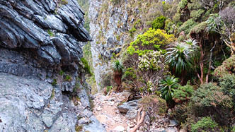
We had a late start on day three at 0815hrs, knowing that it was a shorter day with no side trips planned. Very quickly after leaving Lake Oberon, we came to our first obstacle. A short, almost vertical climb. There appeared to be a few good hand holds and foot rests, but we decided to test out our pack-hauling ability early in the day to give us an indication of how the rest of the day may unfold. As it turned out, this was the only time we needed to pack-haul that day. There was one section which required us to remove our packs and pass them to each other through small gaps in the rocks, but other than that we were
able to navigate the steep gullies slowly and cautiously without removing our packs. The other groups following chose to pack-haul through some of those sections. I would recommend if you found the descent into Lake Oberon difficult, or you find yourself not feeling sturdy on your feet or unbalanced by your pack, the steep gullies would be the place to remove the packs and use ropes to guide the packs down safely but more importantly, get yourself down safely.
This section of the track was relatively easy to follow and well-marked most of the way. There were a couple of sections though at which we needed to stop and have a look around for the correct path. Each time the correct path was easily enough found. It is
Steep gully on route to High Moor
31
important to note that apart from a small tarn close to Lake Oberon, we did not come across anywhere else to fill up on water before High Moor, so carrying enough for this section is wise. The highlight of the day was the view just before the descent down into the High Moor Campsite. It was one of those views where it takes your breath away and you are instantly lost for words. Maybe it was the fact that we had been walking for 5 and a half hours already that made it such a great sight, I’m not sure. What I do know is that feeling has stayed with me as such a fond memory of our hike. It’s moments like these that add so much warmth to the overall experience. Moments like these where you realise how truly blessed we are.
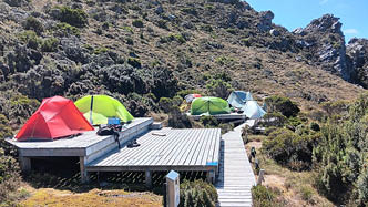
The campsite at High Moor had numerous tent platforms and is surrounded by multiple peaks that made for a fun and relaxed afternoon of exploring as we reached the campsite at 1430hrs. There is also another toilet nearby, alike the other campsites and a small stream for filling up water. I could imagine though, in peak times, that small stream may become close to non-existent.
Day 4: High Moor to Lake Sirona via Mount Aldebaran
~ 7km, 11.8 hrs Side trip: Mount Aldebaran 2.2km return, and took us 1.6 hrs.
Day four was definitely our hardest day.
Today was the day when I realised that the quiet sense of confidence that I had started the traverse with was indeed toeing the line of foolishness. It’s not even so much the technical side of it, but being day 4, the fatigue had started to weigh in. Today we walked much slower, adding considerably to
On way to Haven Lake with view of Federation Peak in the background
High Moor tent platforms
First steep gully descent past High Moor

32 | Bushwalk June 2024
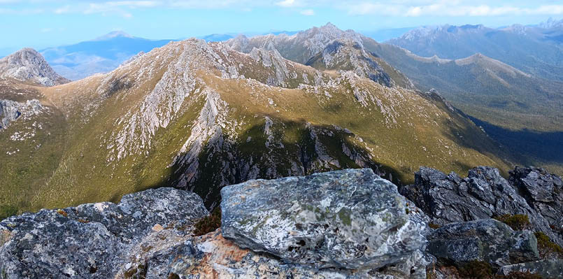
View from Mount Aldebaran
the overall length of the day. We had to carry adequate water for the whole day, knowing there was nowhere to fill up prior to Haven Lake. Everything seemed much bigger, felt much harder. The plan at this point was to get to Lake Sirona with a side trip to Mount Aldebaran, and walk out on day 5 via the last Abel on our list. We had been watching the weather forecast closely and felt it would be safer to avoid the incoming bad weather and make the most of the long summer days.
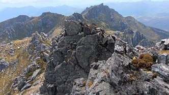
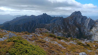
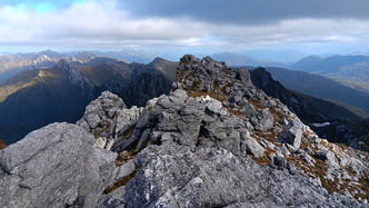
Knowing that we had a big day ahead of us, we set off at 0720hrs. The sun was shining and the wind was to a minimum. Today was the day we met with “The Beggary Bumps”. I had heard and read many things about the Beggary Bumps, but I'm not sure anything could have quite prepared me for what I was in for. At a glance, the Beggary Bumps are a series of prominent peaks. Navigating these bumps requires a whole new level of strength, endurance, careful route-finding skills and a good understanding of the terrain. I was constantly reminded just how delicate parts of the terrain were and I'm not sure I will ever forget the moment of descending one of the peaks and looking down, realising the path was but a small section of dirt relying heavily
on the rocks and plants to keep the track from completely disintegrating beneath our feet. There was a lot of trust being put into the delicate terrain and I couldn’t help but wonder about the impact we were having and how long these tracks will last. I’m not sure I realised at the time just how challenging navigating the constant ascents and descents was or just how big of an accomplishment it would be.
Most hikers set up camp at Haven Lake for the night. We stopped in at Haven Lake for a quick lunch break and commenced the steep climb up to the ridgeline before dropping our big packs and summiting Mount Aldebaran.
Navigating Beggary Bumps
33
The Mount Aldebaran summit sits at an elevation of 1,107 meters. The track to Mount Aldebaran was not clearly marked or easy to find. We found ourselves relying heavily on our map and Garmins. Parts of the track were cairned, but the cairns often led into the thicker scrub which was harder to push through. We stuck to our GPX track and summited by sticking to the left on the rockier sections of the mountain. While we were fatigued and had a moment of considering giving Mount Aldebaran a miss, the summit views definitely proved worthy of the push.
Once down from Aldebaran and back on the main track, we only had less than a kilometre to go to get to Lake Sirona. In our minds, we estimated we could get to Lake Sirona in an hour. Again, we were very wrong. It took us much longer. Although it wasn’t far and nowhere near as technically challenging as the rest of the day had been, our bodies were definitely saying, or rather screaming, ‘enough’. It certainly was a huge relief to make it into Lake Sirona and set up camp before dark.
Day 5: Lake Sirona to Scotts Peak Dam carpark via Mount Scorpio
~ 24km, 8.75 hrs with a 50-metre side trip off the main track to summit Mount Scorpio
Day 5 and our final day of the Western Arthur Traverse. We set off early again at 0700hrs knowing that the most technical part of the traverse was already completed, but we had many kms ahead of us if we wanted to walk all the way out today. Very quickly into the morning we found ourselves summiting Mount Scorpio, the last of the Abels on our list that we wanted to summit, and thankfully the easiest. The summit of Mount Scorpio sits at 1,106 metres elevation and is a short 50-metre scramble off the main track. The scramble is technically easy and we found some cairns that lead all the way to the summit from the main track. Again, the views from the summit were breathtaking and well worth the quick scramble to the top. Once down from Mount Scorpio, our journey of descending from the ranges began. We followed the Moraine K Track for about one and a half kilometres before taking a shortcut known by locals through to the Arthur Plains Track. Here we were back into the open plains and very
exposed to the elements with the majority of the final 17kms providing little to no shade unless crossing creeks. It would be very fair to say that at this point there was little talking amongst us until we reached the car park. We were hot, we were tired, our feet were aching, but what an adventure we had had.
Despite its challenges, the Western Arthur Traverse offers a truly unforgettable wilderness experience for those willing to take on the adventure. From the pristine lakes to its rugged peaks, this traverse truly does showcase the raw beauty and untamed wilderness of Tasmania's southwest. I can now say I have a new and deeper understanding of why this hike has become such a bucket-list destination for outdoor enthusiasts around the world.
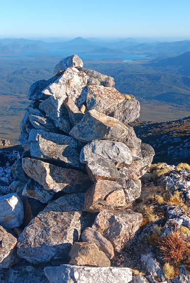
View from Mount Scorpio

34 | Bushwalk June 2024
Rebecca is a resilient single mother of four, residing in a small coastal town in Northern Tasmania. By profession, she is a dedicated Registered Nurse, lending her compassionate care to the local district hospital.
Beyond the walls of the medical facility, Rebecca's spirit finds solace and rejuvenation amidst the untamed beauty of the Tasmanian wilderness. In recent years, she has forged a deep connection with the rugged landscapes and pristine nature that Tasmania offers, discovering within herself a profound love for exploration and adventure. In recent years Rebecca has found a new passion in sharing her love for the wilderness with her children.
You can follow Rebecca’s adventures via:Youtube: @becandthekids Facebook: Bec AndThekids Instagram: becandthekids222

Looking back on the Arthur Range on the way out
<
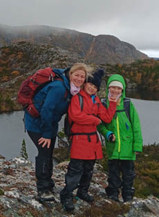
Rebecca with daughters Matilda and Evie at Twisted Lakes

35