The real art of map reading comes with interpreting how individual landscape features fit together in the terrain: saddles connect ridges to knolls to cliffs; gullies form into rivers and valleys. Interpreting how contour lines fit together helps understand the lay of the land and be able to navigate through it.
The image describes a landscape by contours. In words:
Running east to west across the complex landmass is a ridgeline. A ridgeline is a line of high ground, usually with changes in elevation along its top and low ground on all sides. The changes in elevation are the three hilltops and two saddles along the ridgeline. From the top of each hill, there is lower ground in all directions. The saddles have lower ground in two directions and high ground in the opposite two directions. The contour lines of each saddle form half an hourglass shape. Because of the difference in size of the higher ground on the two opposite sides of a saddle, a full hourglass shape of a saddle may not be apparent.
There are four prominent ridges. A ridge is on each end of the ridgeline, and two ridges extend south from the ridgeline. All of the ridges have lower ground in three directions and higher ground in one direction. The closed ends of the U’s formed by the contour lines point away from higher ground.
To the south lies a valley; the valley slopes downward from east to west. Note that the U of the contour line points to the east, indicating higher ground in that direction and lower ground to the west. Another look at the valley shows high ground to the north and south of the valley.
Just east of the valley is a depression. Looking from the bottom of the depression, there is higher ground in all directions.
Several spurs extend south from the ridgeline. They, like ridges, have lower ground in three directions and higher ground in one direction. Their contour line U’s point away from higher ground. Between the ridges and spurs are draws. They, like valleys, have higher ground in three directions and lower ground in one direction. Their contour line U’s and V’s point toward the higher ground.
Two contour lines on the north side of the centre hill are touching or almost touching. They have ticks indicating a vertical or nearly vertical slope or a cliff.
The road cutting through the eastern ridge depicts cuts and fills. The breaks in the contour lines indicate cuts, and the ticks pointing away from the road bed on each side of the road show fills.
Common mistakes
Here are some tips and tricks to identify between standard features.
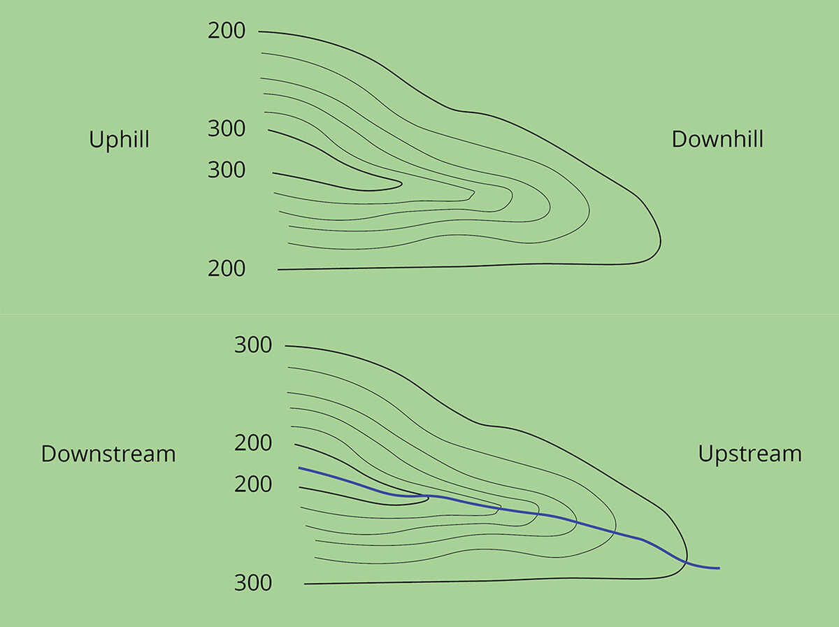
Contour lines on a map depict a spur with the U or V pointing away from the high ground; for a gully, the closed end of the contour line (U or V) always points upstream or toward high ground.
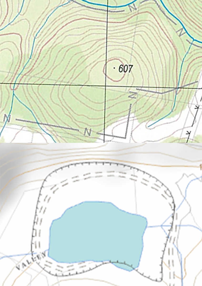
For knolls, contour lines form concentric circles, and there is lower ground all around, whereas depressions have closed contour lines with tick marks pointing toward the low ground.
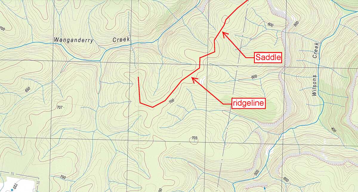
When standing in a saddle, there is high ground in two opposite directions and lower ground in the other two directions. When standing on the centerline of a ridge, there is usually low ground in three directions and high ground in one direction with varying degrees of slope. Be careful not to confuse ‘ridge’ with ‘ridgeline’ here: a ridgeline is a line of high ground, which can rise and fall through saddle features.
Map reading takes practice. One of the easiest ways to do this is to become aware of the shape of the surrounding land at all times, even when driving and walking through an urban area. Most navigation and map reading is about matching up the form of the land with that on the map. Practice recognising and naming key features (knoll, hill, spur, ridge, cliff, valley, etc.). Take maps on all bushwalks and follow the route on the map, even if it’s well signposted. Look at the map regularly and match it with the surrounding landscape.
Some bushwalkers enjoy taking part in Rogaine competitions to improve their navigation. The Bushwalkers Wilderness Rescue Squad also runs an annual navigation competition in NSW.